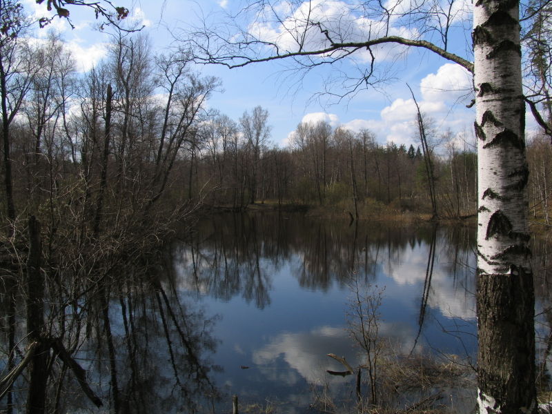
At the junction of three regions of Russia - Moscow, Vladimir and Ryazan lies a beautiful land of emerald swamps and lakes, quiet and unhurried rivers with beaver settlements, amber pine forests filled with grousing wood grouse, light birch forests and aspen forests with brown shadows of leisurely elks - this is Meschera National Park ...
The idea of creating a national park appeared in the early 80s, when the need to preserve the untouched corners of the Meshchera lowland became obvious.
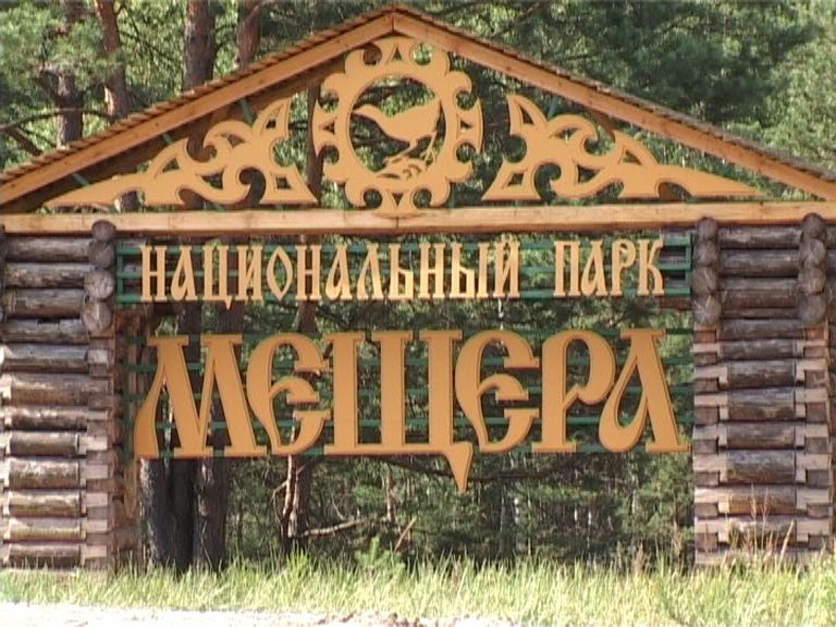
The NP was created by the decree of the Government of the Russian Federation dated April 9, 1992 No. 234 "On the creation of the Meschera national natural park in the Vladimir region". Certificate of state registration No. 403 dated January 18, 2002.
On the lands adjacent to the NP territory in the Vladimir and Ryazan regions, a buffer zone has been allocated with a total area of 46,713 hectares. By order of the Federal Forestry Service of Russia No. 150 of November 4, 1995, the name of the Meschera National Natural Park was renamed to Meschera National Park.
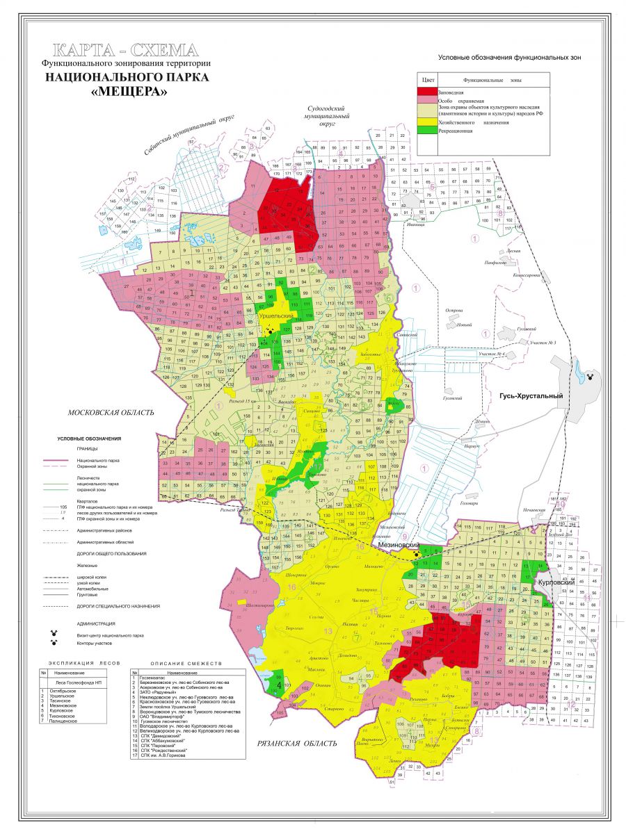
The total area of the park is 118.758 thousand hectares. The territory of the park is located in the southwestern part of the Vladimir region, and occupies 27.4% of the territory of the Gus-Khrustalny region. Geographic coordinates of NP 55017I-55049Ic., 39057I-40038Ie.
WHAT IS A MESCHERA
The name of the National Park is not accidental. Its territory is located within the boundaries of the Meshchera Lowland, in the so-called Vladimirskaya, or eastern Meshchera.
The word "meschera" has several aspects. On the one hand, this is a geographic concept denoting the Meshcherskaya lowland, which is located between the Oka and Klyazma rivers. On the other hand, "Meschera" is a Finno-Ugric tribe, neighbors of Murom and Mordovians, who lived in the 1st millennium AD. along the middle course of the Oka.
![]()
The earliest mention of the cave can be found in the work of the Roman historian Cornelius Tacitus in his work "Germany" (98 AD). Tacitus speaks of the Finns, neighboring with the Wends (Slavs), who lived from ancient times in midnight Europe, “having neither houses, nor horses, nor weapons; eating herbs, dressing with animal skins, sheltering from bad weather under woven branches. "
"The Tale of Bygone Years" lists the peoples who paid tribute to Russia, and the Nikon Chronicle added to the number of the tributaries of Russia the cave. These and other tribes maintained active economic ties with the Slavs, there was a cultural and everyday peaceful assimilation.
The main occupation of the Meshchera was hunting, fishing and bee-keeping.
The term "meschera" is translated by Tacitus as "forest people". In Finns, "metsa" means forest, thicket, "mesi" - honey, nectar, in the Mordovian dialect "mesht" means a bee.
Thus, the meschera - tribes of forest people, hunters, bee keepers, fishermen with a small economy, small plots of land, livestock, were able to weave and make bronze jewelry.
In the 13th century, the meschera was mentioned in the "Explanatory Paley" and other Russian chronicles.
Archaeologically, the existence of the Meshchera is confirmed by finds in the Yegoryevsky District of the Moscow Region (finds from 1870, dated to the 11-12th centuries), in earthen burial grounds near Sudogda.
Over time, the Meshchera became Slavic, dissolved in the Mordovians and Tatars. But some of it has retained its identity.
Unfortunately, by the 17th century the Meshchery language had disappeared, at the turn of the 19th and 20th centuries it was difficult to distinguish Russians from Meshcheryaks.
The original population of the Meshchera region was represented by the Volga-Finnish ethnos. According to N.M. Karamzin, these peoples were subordinate to the Goths. They settled in high places near rivers and lakes, among dense forests and almost impenetrable swamps. In the X century. these tribes were colonized by the Slavic peoples. According to V.O. Klyuchevsky, colonization took place gradually and peacefully. The indigenous people dissolved among the newcomers, accepting their customs, language, and faith.
In the turbulent era of Peter I, industry began to develop in Russia - metallurgy, linen production, glass making. The abundance of forests, the excellent quality and low cost of local raw materials (quartz sand and dolomite), the availability of labor - contributed to the rapid development of the glass industry in the Meshchera region.
In the middle of the 19th century, the territory included in the Meschera National Park karta_arefino.jpg was administratively subordinate to the Yagodinsky volost of the Vladimir province, the Kasimovsky and Yegoryevsky districts of the Ryazan province. The cult and cultural centers of the parish at the end of the 19th century became the village. Palischi and Erlek churchyard.
bittern 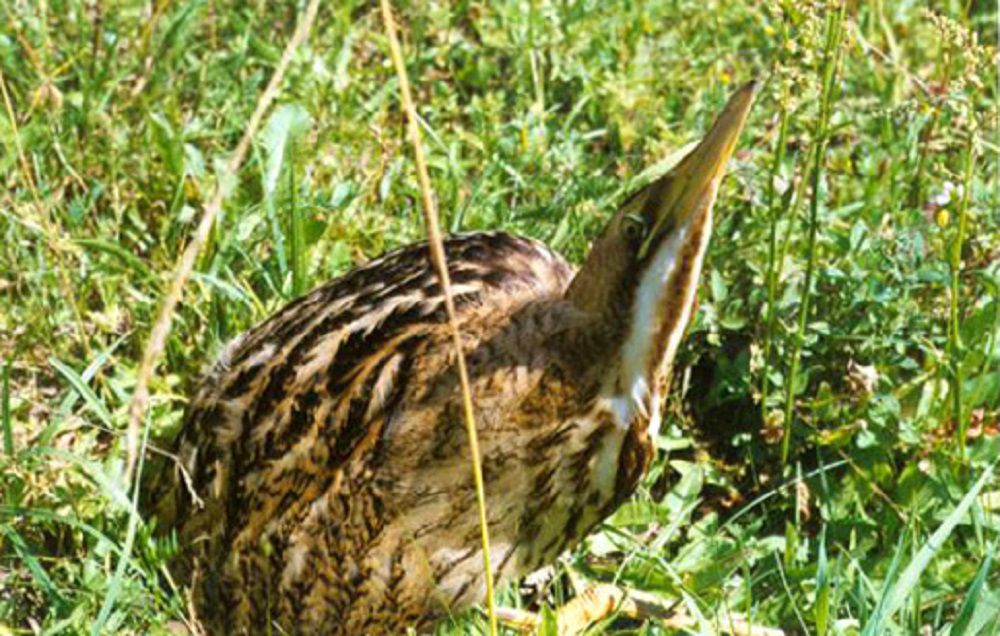
GENERAL INFORMATION
National Park "Meshchera" was created in 1992 on the territory of the Vladimir region to preserve the natural complex of the Meshchera lowland. The national park is located in the southwest of the region. In the west, the park borders on the Moscow region, on the south side of the park is adjacent to the Meshchersky National Park of the Ryazan Region. The national park occupies 118,900 hectares of land, of which 61% are allocated to the park, and 39% are allocated for economic activities to various owners.
The landscape of the park, formed in antiquity, is a swampy plain covered with pine and birch forests. The Meshchera Lowland is located in the southern part of the Moscow syneclise, the trough of the crystalline basement of the Russian Platform, composed of Archean and Proterozoic rocks.
The formation of the Meshchera relief was greatly influenced by the location in the zone of the Shilovsko-Vladimirsky trough, to which the lowest central part of the Meshchera lowland is confined, within which the Meshchera national park is located. The maximum fluctuation of the relief within the boundaries of the park is 36 m (112-148 m above sea level). The landscapes of the national park are typical natural complexes of the Polesie type (moraine-water-glacial plains, zandras, etc.), among which there are areas of aeolian hilly sands.
CLIMATE
The climate of the park, in general, is moderately continental, characterized by well-defined seasons. Humid air masses from the Atlantic penetrating with cyclones in winter cause a weakening of frosts and snowfalls, in summer - a decrease in temperature and rains. Arctic masses cause a sharp cooling in winter, and strong heating of the surface in summer. The average annual temperature in the city of Gus-Khrustalny is +3.7 ° C, the average annual rainfall is 571 mm. About 70% of precipitation occurs during the warm period (April-October).
The duration of the period with temperatures above +10 ° C is 130-145 days. Average monthly above zero temperatures occur in the period from April to October: frosts stop on average on May 10-12. A stable snow cover sets in at the end of November and breaks down in the first ten days of April. The average snow depth is 41 cm. The number of days with snow cover is 140-145. The average January temperature is -11 ° C, the minimum is -44 ° C.
In spring, the air warms up quite quickly, snow melting begins in mid-March, and active vegetation of plants begins in early May. In summer, the western transport of air masses prevails. The warmest month is July (+18.4 ° C), the maximum temperature is +37 ° C.
Warm weather lasts until the end of September. A significant cooling begins in October. Frost starts at the end of September. By the beginning of November, the average daily temperature goes over 0 degrees.
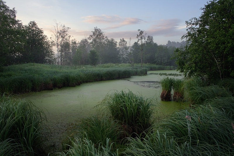
Water bodies
The territory of the park belongs entirely to the Oka river basin. The main rivers are Buzha (about 80 km within the park) and its left tributary Pol (45 km). The density of the river network is 0.22 km / sq. km. The average drainage module ranges from 0.7 to 3.5 l / s. sq. km.
The underground runoff is estimated at 2-2.5 l / sec. sq. km. The type of food is mixed. The Buzha and Pol rivers meander strongly in the middle course, their average channel width is 10-15 m, in the lower one, 15-20 m, depth 1-1.5 m, oxbow lakes are often found.
In the southwestern part of the park, Buzha flows into Lake Svyatoe, the northernmost of the Klepikovo lakes system in the upper reaches of the Pra. The area of the lake is 500 hectares, of which 200 hectares are included in the boundaries of the park.
Lake Svyatoe is shallow (1-1.5 m), water-glacial origin, heavily overgrown, with sandy, in places peaty shores. Other lakes are small in area, shallow, water-glacial origin and oxbow in river valleys. Half a kilometer to the east of Saint there is a small thermokarst lake Glukhoe with a depth of more than 15 m. The total area of lakes in the park reaches 600 hectares.
The rivers Tasa and Karaslica (flowing through Lake Spudninskoe) also flow into Buzha; Poserda (Soroka) also belongs to the Pra basin. The southeast of the park belongs to the basin of the Gus River, here are the upper reaches of the Shurovka, Pinsur and others.
Swamps play a significant role in the feeding of rivers. Rivers, as a rule, flow in weakly expressed valleys, the banks are often swampy and peaty. Many rivers are canalized by drainage ditches.
The regime of rivers is characterized by spring floods, summer low-water periods, a rise in the level after heavy rains, an increase in runoff in autumn and a low winter low-water period. The flood is extended in time: late March - late April, the water level rises up to 3 m. Freeze-up begins on average on November 15-20, the average duration of freeze-up is 100-150 days, the maximum is 175 days. The ice thickness ranges from 20 to 60 cm.
Soil
The soil cover of the Meshchera lowland is very distinctive.
Sandy deposits served as the basis for the formation of sod-podzolic soils. Due to the flat, low relief, waterlogged and boggy soils are widespread. In Meshchera, there are also podzolic soils characteristic of the subzones of the northern and middle taiga.
Registered species
mushrooms - 24
lichens - 23
mosses - 43
Lyciformes - 4
fern-like - 11
gymnosperms - 3
angiosperms - 661
fish - 30
amphibians - 10
reptiles - 5
birds - 186
mammals - 42
Flora and vegetation
In terms of botanical and geographical zoning, the park's territory is located at the junction of the North European taiga province of the Eurasian taiga region and the East European province of the European broad-leaved region. Due to the border character of the territory, the vegetation cover of the park traces the features of the southern taiga, coniferous-deciduous and deciduous forests.
Due to the border botanical and geographical position and local peculiarities of the region, its floristic diversity is very rich. In the local flora, taiga species, plants of coniferous-broad-leaved and broad-leaved forests, bogs of various types and even elements of the steppe flora are significant.
In general, the flora is boreal-temperate. The flora is dominated by species of circumpolar, Holarctic and European boreal distribution.
The species of plants of the families Astrovye, Cereals, Sedge, Pink, Cabbage, Legumes, Cloves, Noricum and Buttercup are represented to a greater extent. Elements of the European nemoral complex of deciduous forests play an important role.
The forest-steppe and steppe elements, on the contrary, are numerous, but their role in the composition of the vegetation cover is small. Most of all forest species, followed by weed-ruderal, then meadow, marsh, meadow-edge, aquatic and coastal.
The vast majority of flora species are herbaceous plants, perennials prevail among them. Annual plants are numerous. The number of tree-shrub and dwarf shrub species is small - about 70 species.
Forests make up most of the park's territory (forest cover is about 70%). Pine forests and birch forests derived from them predominate. Most of the forested land is occupied by conifers - 60%; of which Scots pine - 59%. Spruce forests (common spruce) account for about 1%.
Pine forests occupy various habitats, from dry (white moss pine forests) to waterlogged (sphagnum pine forests with wild rosemary). Small-leaved forests are almost always secondary and derivative, occupying 40% of the forested land. Birch forests are especially widespread (downy birch, drooping birch, or warty) - 36%. Aspen forests are much less widespread - 2%.
Black alder forests are located in river valleys, depressions and occupy 2% of the forested land. Broad-leaved forests of English oak occupy insignificant areas (about 100 hectares) and are represented mainly by oak forests in river valleys. Mixed coniferous-deciduous forests (zonal type of vegetation - the final stage of succession) are found somewhat more often, but they also do not cover large areas, occupying a subordinate position in the vegetation cover. On the territory of the park, bilberry and lingonberry groups of forest types are widespread, occupying 43% and 21% of the forest area, respectively.
In dry, light places, there are thickets of raspberries and vast clumps of strawberries, in swamps - cranberries. Vast areas (about 5 thousand hectares) are occupied by swamps with their inherent vegetation.
Fauna and animal world
In terms of faunism, the Meshchera lowland does not differ significantly from other natural regions of Central Russia. The fauna of birds and mammals, as well as other groups of animals, is dominated by species of European origin. Taiga forms occupy a subordinate position.
The outstanding importance of Meshchera in general and the park in particular for the preservation of the animal world is determined not by its faunistic originality, but by the fact that the whole complex of habitats of the subzone of European coniferous-deciduous forests is very fully represented here.
Forests in combination with bogs form a vast forest bog complex, which supports the conservation centers of a number of species of large mammals, as well as birds that need extensive individual areas. This territory has long been famous for the abundance of forest animals and birds, as evidenced by the certificates of gift of the Ryazan princes to local monasteries. Wildlife hunting, bird hunting and fishing, along with beekeeping, were among the traditional forms of nature management in Meshchera.
Fauna and animal population have the features of strong anthropogenic influence. The most numerous are white hare, squirrel, fox; common elk, wild boar, beaver, raccoon dog, American mink, weasel, ermine, wolf, pine marten, badger; occasionally there are European hare, polecat, otter.
Traces of the entry of the brown bear and the habitat of the endemic of the Eastern European fauna - the Russian desman were noted. Among birds, the following are quite common: gray crane, capercaillie, black grouse, hazel grouse, marsh harrier, red-footed falcon, corncrake. Rare are the white stork, gray heron, bittern, witch, gray partridge, great bodew, curlew, woodpeckers - green, gray, three-toed, white-backed, gray shrike, etc.
Reptiles are represented by the spindle, the quick and viviparous lizards, the common snake and the common viper. Amphibians are represented by common and crested newts, two species of toads, frogs: lake, pond, ostromordy, grass frogs, as well as garlic and red-bellied toad. Common fish include the common loach, common roach, perch, pike, crucian carp, and Amur sleeper (invader). Rare - blue bream, white-eyed. About 520 species of Lepidoptera and 149 species of weevils are registered in the park.
Species included in the Red Book of the Russian Federation
Angiosperms
Neottianthe cucullata (L.) Schltr. - Nest flower nodule
Orchis baltica Klinge - Baltic orchis
Birds
Golden Eagle (Aquila chrysaetos)
Great curlew (Numenius arquata)
Great Spotted Eagle (Aquila clanga)
Serpentine (Circaetus gallicus)
Oystercatcher (Haematopus ostralegus)
Lesser Tern (Sterna albifrons)
Common Gray Shrike (Lanius excubitor excubitor)
White-tailed eagle (Haliaeetus albicilla)
Lesser White-fronted Goose (Anser erythropus)
Peregrine Falcon (Falco peregrinus)
Osprey (Pandion haliaetus)
Central Russian ptarmigan (Lagopus lagopus rossicus)
Owl (Bubo bubo)
Black stork (Ciconia nigra)
Mammals
Giant nocturnal (Nyctalus lasiopterus)
Russian desman (Desmana moschata)
PARK "Meschera"
Excursion travel opportunities for
National Park "Meschera"
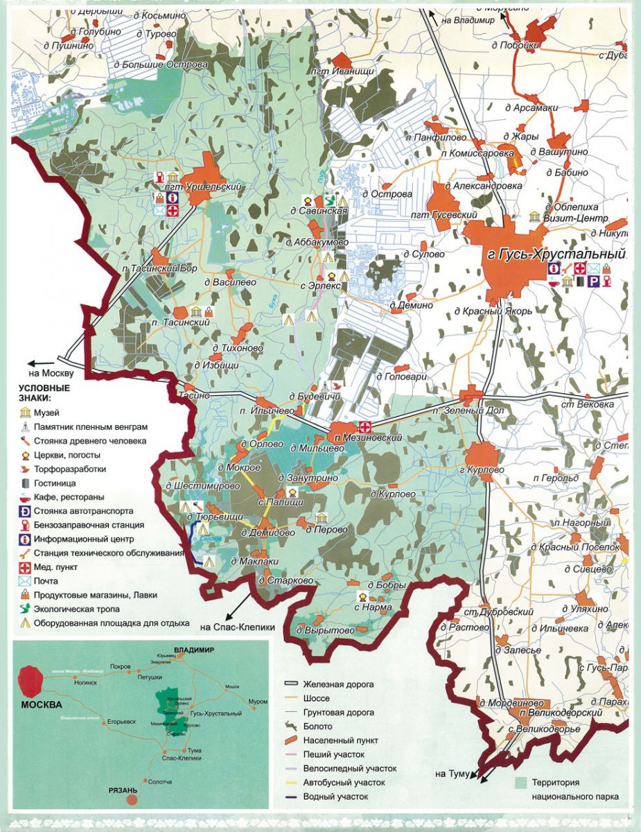
The visit center is located in the city of Gus-Khrustalny on the territory of the Khrustalnaya tourist center (at the entrance to the city from the side of Vladimir). In the visitor center there is a small exhibition hall with a model of the park, with a collection of butterflies living in the park and a collection of insects. Here we get general information about the Meschera National Park.
The Museum "The World of Birds of the Meschera National Park" is located in the village of Urshel (45 km from the town of Gus-Khrustalny). The exposition is located in 3 rooms, it is a zoological collection, including about 200 exhibits of stuffed birds, eggs and nests.
The open-air museum complex “Old Russian city. Russian Compound "(36 km from the town of Gus-Khrustalny). The museum complex is located in the village. Tasinsky in the open air, talks about the peculiarities of the construction of wooden fortresses and the peasant life of the Russian village. The bear Marya Potapovna lives in the courtyard, who gladly accepts treats from visitors. The excursion program includes entertaining theatrical moments. On request, it is possible to have tea from a Russian samovar and lunch in a wicker arbor.
Ecological trail "Forest world Meshchera" is located next to the "Podvorie". Its total length is 3 km. The trail is decorated with images of animals living in the park and characters from Russian fairy tales; along the route there is a wooden gazebo for rest.
The temple of the early 19th century in the village of Erleks (25 km from the town of Gus-Khrustalny) is located 1.5 km from the road, in the forest, on the banks of the Pol River.
Recreation areas on the banks of the Pol and Buzha rivers are equipped recreation areas with tables, toilets, and equipped fireplaces.
All the listed objects are located on the same route along the road "Gus Khrustalny - Urshel". If you visit all the sites, the full excursion program in the park will take 5-6 hours. Various program options are possible (power on, folk or game program)
Holy lake
HOW TO GET THERE, WHERE IT IS
- By bus: Moscow - Gus-Khrustalny from the bus station (metro Shchelkovskaya) - 5 hours.
By car: along the Moscow - Vladimir highway (M7) to Vladimir ~ 170 km, then to the south to the town of Gus-Khrustalny; or by car: from Moscow along the Yegoryevskoe highway ~ 140 km to the town of Spas-Klepiki, then to the east along the highway to Tuma, Kasimov ~ 25 km to the town of Tuma, then to the north 47 km to the town of Gus-Khrustalny.
By electric train: Moscow - Vekovka from Kazansky railway station - to the station. Peat product (Tasinsky siding) - 4 hours.
Accommodation options:
On the territory of the park - a summer version of a tent on a recreation area;
Tourist complex "Khrustalny", Gus-Khrutsalny - summer houses;
Tel .: (49241) 2-53-31
Hotel "Meshcherskie Zori", Gus-Khrustalny
Tel .: (49241) 2-05-48
Hotel "Barinova Roscha", Gus-Khrustalny
Tel .: (49241) 3-19-01
FLORA PARK
General information about the flora of the NP "Meshchera"
I. Mushrooms - 24 species
II. Lichens - 166 species
III. Vascular plants - 872 species
Mossy - 61 species
Higher vascular plants - 811 species
1. Paparactoid - 12 species
2. Horsetail - 5 species
5. Angiosperms - 787 species
Monocots - 181 species
Dicotyledons - 606 species
The ecological ranges of habitats, in addition to climax areas (with mature zonal soil formed and an established balance between the processes of deposition and decomposition of plant residues), includes both excessively dry and excessively moist habitats. The so-called xeroseries are associated with the conditions of excessive dryness; hydroseries are characteristic of excessively humid places.
CONIFEROUS FORESTS
Formed by pine and spruce. Pine forests are the most widespread formation of the national park. They are characteristic of immature habitats of different stages of development. Pine forests are confined to both extremely dry and excessively humid places and are subdivided into three groups: pine forests of the xerose series, pine forests of the mesotrophic hydroseries, and pine forests of the oligotrophic hydroseries. Each of these groups, in addition to the growing conditions, is also united by the unity of the floristic composition and the direction of dynamic processes.
Pine forests of the Xerose series are widespread and predominate in area in places with a well-pronounced ridge-hilly relief formed by sandy deposits. They are typical for outwash plains and above-floodplain terraces of the Buzha and Pol rivers. The pine forms characteristic white-moss pine trees. On the edges and clearings in such pine forests, in addition to the lichen cover, grow: heather sedge, round-leaved bellflower, mountain insect, plain wormwood, as well as open lumbago, uncharacteristic for the Meshchera lowland, which penetrate along river terraces uncharacteristic for the Meshchera lowland, vineyard breech, sheep thyme, white sheep.
With the development of a cover of green moss, white moss pine forests turn into green moss pine forests. With a strong development of the moss cover, it begins to hinder the renewal of pine, but as the lymphatics and lingonberries grow, pine renewal is observed everywhere. By the age of 70-80 years of age, a lingonberry layer is usually formed in green moss pine forests. Lily of the valley pine forests with a stand age of at least 100 years also belong to this series. Due to logging and fires, they are represented only by small fragments. Under the crowns of pine trees, on a sparse moss cover, a cover of lily of the valley is developed with an admixture of fragrant kupena, hairy pegs. In this type of pine forests, there is a renewal of mountain ash, warty spindle tree, and lemongrass oak.
Pine forests of the mesotrophic hydroseries prevail in area on flat, weakly dissected watersheds, occupying all excessively moistened places with peat-gley or gley-podzolic soils. In areas with dunes or ridged relief, they are confined to inter-dune depressions and the outskirts of oligotrophic bogs.
The treeless stages of the mesotrophic hydroseries - white-mustache wastelands and burnt-out areas, as well as the early stages of the hydroseries, are occupied by carpets of moss, inhabited by downy birch, which over time forms a bilberry birch forest. The renewal of the pine can occur simultaneously with the birch or be somewhat delayed, but when the pine is 60-80 years old, dominance finally passes to it.
Later, under the canopy of the pine, the lingonberry grows and the renewal of the spruce begins. On the leveled plots, one can distinguish a pure lingonberry pine forest, where as characteristic species there are plants of the initial stages - annual lyca, marsh violet, blue thunderbolt, graying reed grass. When the spruce enters the first tier, the lingonberry is replaced by dead-covering areas, where there are usually individual specimens of the two-leaved mine, the European cotterus, the Carthusian thyme, and hairy pegs.
Oligotrophic pine forests are located in small areas in between depressions. They are formed by pine with various admixtures of downy birch. The near-stem elevations at earlier stages are tightened by sphagnum and common cranberries, which grow together with marsh and hamedaphny bogulnik, then the sphagnum mosses die off and are replaced by a cover of green mosses. In the hollows are bog sphagnum, common white cotton, vaginal cotton grass. By the time the crowns close, a continuous cover of lingonberry and Schreber's pleurosis develops.
Spruce forests are confined to the habitats of the mesotrophic and eutrophic hydroseries, where they form the final communities, as well as to climax habitats. There are almost no large spruce tracts in the park. Small areas of spruce forests are confined to the central (east of the village of Mezinovsky), northwestern (the slope of the Ostrovsky bog basin), southern and southeastern parts of the national park.
In the floodplains of forest streams in the southeastern part of the park, there are so-called tamed spruce forests. Spruce specimens are located on hummocks bearing the usual cover of eutrophic spruce forests.
Spruce forests of climax habitats, which are widespread in the Meshchera lowland in areas of moraine plains, grow in the northwestern part of the park (the Vyunitsa river basin), as well as in the interfluve of the Pol and Buzha rivers. The dead-cover stage in young plantations is replaced by an oxalis spruce forest, into which species of nemoral broad-grasses are introduced. There is a further renewal of maple, linden and oak, as well as hazel.
Buzha river
Broadleaf forests
Broad-leaved forests in the Meschera National Park are represented by only a few hectares of fragments of floodplain oak forests in the valley of the river. Buzha stretches from the Gus-Khrustalny - Urshelsky highway to the village of Mokroe. They are dominated by lily of the valley, the shrub layer is formed by the May rosehip.
Small-leaved forests
Most of the small-leaved forests in the national park are derived. An exception may be black alder forests and some downy birch forests. Since the territory of the park has undergone intensive economic use, small-leaved forests play a significant role.
Birch forests of the formations of drooping birch and downy birch are represented by several types. They form independent communities with single-species stands occupying certain places in hydroseries and demutational climax rows.
Drooping birch, as a rule, forms plantations in climacteric habitats. Birch forests of this type, in the absence of anthropogenic pressure, quickly turn into spruce forests. Hanging birch sometimes settles in dry meadows. In young birch forests, grass stands of meadow and meadow-forest species are developed, which is gradually thinned out, and spruce is gradually replacing birch. Pyrogenic birch forests are dominated by blueberries, which can be under the canopy of spruce forests for a long time, which have replaced these birch forests.
Downy birch forms plantations in several types of habitats, settling at the level of non-forest stages of the mesotrophic hydroseries and participating in the demutation rows of mesotrophic and eutrophic spruce forests.
Mesotrophic birch forests develop on the carpet of sphagnum and polytrichum, often at the same time as pine. In young forests, birch is always more, but gradually dominance passes to pine. In addition to mosses, there are always graying reed grass, kumanik, forest horsetail, and in areas of ground fires, blue thunderbolt and common heather. In the future, bilberry birch forests are formed here, and blueberries and other forest plants are confined to increases in tree trunks. Blueberry birch forests can be both primary and secondary.
Secondary birch forests develop on dry meadows of the mesotrophic hydroseries. They are characterized by a cover of meadow-forest species, which, with constant haymaking and grazing, can remain under the canopy for quite a long time. However, with the cessation of anthropogenic impact, the dominant blueberries and lingonberries, as well as hairy ogum, double-leaved mine, and drupe, settle here. Over time, such communities turn into lingonberry pine forests or mesotrophic spruce forests.
Eutrophic birch forests replace short-term stages of willows that appear on pike and red oyster meadows. They often develop on the edges of black alder forests and, as a rule, do not differ from them in the herbaceous cover, having under the canopy, in addition to meadow species, elements characteristic of eutrophic spruce forests, and species of wide grasses.
Aspen forests are characteristic only of eutrophic habitats, which are rare in the park. Aspen forests participate in the demutational rows of spruce forests, which form the final stage of the eutrophic hydroseries. Also, aspen forests develop directly on cutting areas in old spruce and spruce-broad-leaved forests with nemoral grass cover. In such aspen forests with a wide-grass cover, maple and oak are renewed, while spruce is practically not renewed. Small areas of aspen forests are located along the drained edges of black alder forests.
Black alder stands are an early stage of the eutrophic hydroseries. More or less large massifs of black alder forests are widespread in the floodplains of rivers and streams, as well as in the estuarine parts of the vast swamp massifs associated with them. In young black alder forests that appear in the place of damp meadows, naked meadowsweet, forest reeds, common loosestrife, bald violet, and marsh violet dominate. Curly hops and bittersweet nightshades are also characteristic.
Specific communities that can exist for a long time - black alder bogs - are confined to highly watered places. They represent a combination of various initial stages of the hydroseries (the dominant sedge, the riverine horsetail with the participation of the poisonous milestone and the iris) and individual specimens of alder, forming high hummocks. On hummocks under the crowns, typical forest species develop, characteristic of spruce forests of the eutrophic hydroseries, into which black alder bogs eventually pass.
Dry meadows
All dry meadows of the national park owe their existence to human activities. They originated in the place of deforested forests and remain treeless only as long as they are used as hayfields or pastures. In the habitats of the Xerose series, meadow stages are represented by a cover.At the background of an open grass cover, interspersed with non-turfed areas, there are species characteristic of Xerose series pine forests: small sorrel, common hawk, stonecrop, cat's paw, plain wormwood.
The meadow stage of the mesotrophic hydroseries is formed by the communities dominated by the whitewings. The mesotrophic meadows of the national park are overgrown with birch together with pine, however, when used as pastures, they turn into pure white-mouthed wastelands.
Dry meadows of the eutrophic hydroseries are formed by pike. They almost always contain species of the previous stages of succession - naked meadowsweet and river gravilat. In the future, together with pike and red fescue, meadow sivets, erect cinquefoil, and red fescue dominate. The abundance of pulmonary genotica is very characteristic. These meadows are overgrown with downy birch, willows, aspens.
Dry meadows of climax habitats are represented by the fragrant spikelet community. Forbs are represented by the common nivyannik, the spreading bell, the St. John's wort, the cornflower meadow, the Veronica of the oak, the meadow clover, the soft bedstraw, etc. These meadows are found in very small areas near settlements in the central part and in the south of the park.
Floodplain meadows
Small areas of floodplain meadows typical of the floodplains of the Buzha and Pol rivers (along the length from the Gus-Khrustalny-Urshelsky highway to the main railway) are represented by communities of eutrophic hydroseries, as well as specific single-species groups of long-rhizome grasses in places with noticeable deposition of sandy sediments - two-branch reed, awnless rump, creeping wheatgrass.
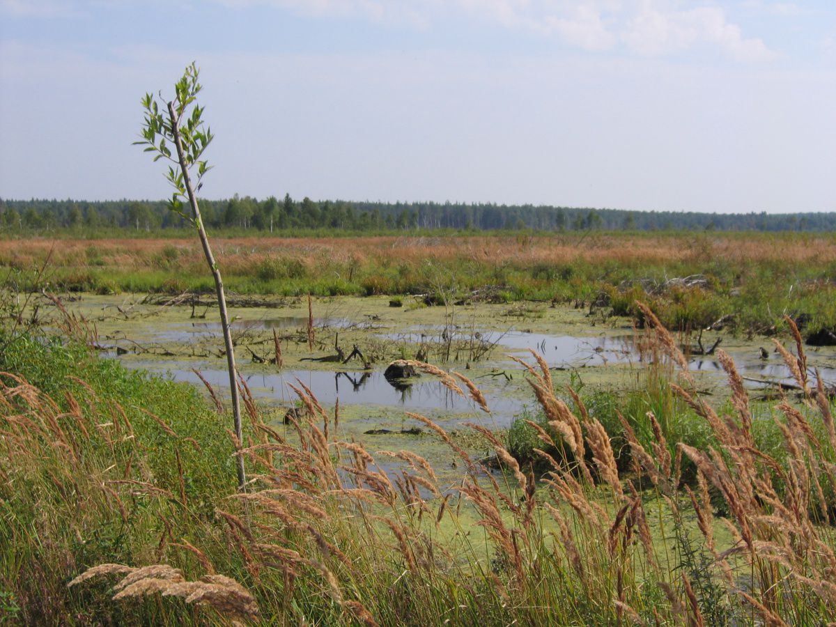 Swamps
Speaking about swamps, it should be emphasized that before the economic development of the territory of the national park, they accounted for ¼ of the area. However, now most of the large bog massifs (Ostrovskoe, Baksheevskoe, Mezinovskoe, Garinskoe, Tasinskoe, Ivanishchevskoe, Ostrovskoe) have been drained and developed. On a thin layer of undeveloped peat, either pike meadows (in conditions of haymaking) or young birch forests have formed. In burnt areas
Most of the bogs in the national park are eutrophic. They stretch for many kilometers in the floodplains of the Buzha and Pol rivers along the shores of Lake Svyatoe and are represented mainly by large sedge communities with hygrophilic species of forbs, with the participation of marsh calla and marsh cinquefoil. Forest stages are represented by black alder bogs. a blue lightning grows.
Areas of mesotrophic bogs that have survived drainage and peat extraction are often used as hayfields. The sphagnum mosses cover is dominated by the nosy sedge, the graying reed grass, the marsh cinquefoil, and the common bent grass. Of the rare characteristic species, we note the reed grass
unnoticed and lash-like sedge.
Oligotrophic bogs, occupying small interstellar depressions, are usually covered with sphagnum pine forests.
![]()
TOURIST FACILITIES
Visit center
The visit center is located in one of the most beautiful and picturesque places of our city in a 200-year-old pine grove on the territory of the tourist complex "Crystal". In the exhibition hall of the visit center, visitors get an initial idea of the territory of the national park, its structure and functions.
The main object of the inspection is the model of the Meschera National Park, made on a scale of 1: 10000. When performing work on the layout, aerial and space photography, photographs of churches were used. The model is electrified.
The visitor center houses the largest collection of lepidopterous insects (lepidopter fauna) in the Vladimir region. It contains over 700 species of butterflies from 44 families living on the territory of the National Park.
Collection No. 2 - "Coleopter fauna of the Meschera National Park" (created in 2007) is a zoological collection that contains 449 species of coleopteran insects (beetles), of which 8 species are subject to protection in the Vladimir region dscn0001__
Collection No. 3 - "Lichen flora of the Meschera National Park" (created in 2008) includes 22 species of lichens, among which there are representatives of all the main life forms of lichens (scale, foliose and bushy).
The exhibition hall hosts contests, quizzes, holidays, meetings, seminars, conferences, excursions, classes, exhibitions of drawings, photographs and creative works.
Museum of Nature
"The bird world of the Meschera National Park".
In 2004, the Nature Museum “The World of Birds of the Meschera National Park” (Urshelsky village) was opened. Today there are about 200 exhibits in it.
This is a zoological collection of stuffed birds living in the park (131 pieces), and a unique collection of bird eggs (49 different species), the formation of an exposition of bird nests has begun (at the moment there are already 20 species).
Every year, the park's staff hold events dedicated to birds. Several dozen children's creative works, as one of the results of these events, are presented in one of the halls of the museum.
Local history complex
“Old Russian city. Russian Compound".
In the museum “Old Russian city. Russian courtyard "(start of construction - 2004), located in the village of Tasinsky, at the moment there are 3 expositions.
The open-air expositions showcase various types of hedges, wells, Russian baths, haystacks, woodpiles and roof coverings that were once used by our ancestors.
The exposition "Russian hut" recreates the interior of the hut of the Meshchera peasants of the 19th - early 20th centuries.
In 2006, the exposition "Old Russian Settlement" was opened, acquainting visitors of the museum with the types of buildings characteristic of the Middle Ages.
Having visited our museum complex, you can plunge into the wonderful world of antiquity, a world that has long gone or gone, a world in which the voices of ancestors are heard ...
Ecological trails.
Large ecological trail "Meeting with Meshchera"
This trail runs through the entire National Park from north to south from the village of Savinskaya to the lake. Holy. This is a multi-day trail, 68 km long, including hiking, cycling, car and water tourism. The trail is equipped with 6 stationary parking lots for rest and overnight stay.
The route includes excursions: through the National Park, along the Svyatoe Lake, to the Church of the Holy Trinity (Erleks village), as well as rafting on rubber boats on the Buzha River and much, much more. This route belongs to educational and tourist trails.
Ecological trail "Forest world Meshchera".
“There on unknown paths
Traces of unseen beasts,
The hut there, on chicken legs
Stands without windows, without doors.
There the forest and the valley of visions are full ... "
(A.S. Pushkin)
There is every reason to believe that the great poet wrote these lines about the Meshchera region. Where, if not in the mysterious Meshchera, can the heroes of Russian fairy tales live, and amazing transformations take place? Where, if not in our forests, amid the impenetrable swamps, do they really belong? Doubt? Then, come to the Meschera National Park and see for yourself by walking along a specially equipped ecological trail.
Small ecological trail "Forest world Meshchera", opened in 2007. The trail was laid in the area of the village of Tasinsky and together with the museum "Old Russian city. Russian Compound ”is a single ethnographic complex. The trail route is circular, the total length of the trail is about three km.
The Fairy Tales Trail is a continuation of the excursion route.
"There the prince in passing
Captivates the formidable king
There in the clouds, in front of the people
Through forests, through fields
The sorcerer carries the hero.
In the dungeon there the princess grieves,
And the gray wolf serves her faithfully.
There is a stupa with Babayu-Yaga
It walks, wanders by itself ... "
She acquaints travelers with fairy-tale characters: Baba Yaga, geese-swans, Ruslan and Lyudmila, Ivan Tsarevich, Emelya, etc.
Meshchersky forest is beautiful at any time of the year and creates a fabulous impression. That is why the characters of Russian fairy tales are so organically woven into the Meshchera landscapes.
Ecological trail "Travel along the Ryazan tract".
The trail starts from the equipped recreation area on the river. Pol with a view of the Holy Trinity Church (22 km from the town of Gus-Khrustalny), goes along the picturesque left bank of the Pol river along the old Ryazan tract to the equipped recreation area "Sosnovaya". The length of the route is about three km. The trail is equipped with notices, information stands, a diagram of the park, various biotechnical structures, bird feeders. Traveling along the trail is combined with rest on the equipped site "Sosnovaya", where vacationers are given the opportunity to arrange a camping!
Ecological trail "The road to the temple".
In 2011, work was completed on the creation of another educational and educational ecological trail "The Way to the Temple". The trail leads to one of the most beautiful monuments of religious architecture of the 19th century - the Church of the Holy Trinity. The route of the trail is linear, the total length is about 2 km.
Traveling along the trail allows visitors to take a walk along the dendrological section of the park and immerse themselves in the history of Meshchera.
Ecological trail "Travel to the world of Meshchera swamps".
Opened in 2013. The main purpose of the new ecological trail is environmental education of the inhabitants of the region about the purpose of swamps, about representatives of the flora and fauna of bogs, about the many-sided work that is carried out in our wetlands, both for scientific research and in order to restore drained bog massifs ...
Tourist routes.
Route number 1 "Meeting with Meshchera".
Location: from the village of Savinskaya to the lake. Holy, 68 km long.
5 - day route including hiking, cycling, car and water tourism. Equipped with 6 stationary parking lots for rest and overnight stay (every half day of the trip). Designed for tourists who want to get acquainted with the nature of the Meshchersky region, who are not afraid of mosquitoes, overnight in a tent camp and food cooked on a fire!
Route number 2 "Along the reserved Meshchera".
Location from the city of Gus - Khrustalny to Lake Svyatoe, 158 km long. 5 - day route, including hiking, car and water tourism. Equipped with 2 parking lots. It assumes accommodation at the Khrustalnaya tourist center, provides 2 lunches at the recreation area and an evening ear on the Svyatoe lake. The program includes a bus tour of the city and a walking tour of the National Park.
Route No. 3 "The Land of Glassmakers".
Location from the city of Gus - Khrustalny to Lake Svyatoe, 200 km long.
4 - day route including hiking, car and water tourism. Equipped with 2 parking lots for rest and overnight stay. Acquaintance with the history of the development of glass making in the Meshchera region. Lunch and overnight at the recreation area are provided.
Route number 4 "Weekend in the reserved Meshchera".
Location from the town of Gus - Khrustalny to the village of Erleks, 122 km long.
3 - day route, including hiking, car types of tourism. Equipped with a recreation area, notices and information stands. Accommodation of groups is provided. This is a weekend getaway for the whole family in a picturesque setting. The program includes a visit to the Visit - center, excursions to the collections of insects and lichens, a visit to the Church of the Holy Trinity.
Route number 5 "Winter's Tale in Meshchera".
Location from the town of Gus - Khrustalny to the village of Erleks, 58 km long.
One-day route that includes hiking, car and ski tourism. Equipped with a recreation area. The route offers to admire the Meshchera region in winter.
Animation programs.
Weaving animation elements into the canvas of excursion programs (solemn meeting of guests, archery, meeting a guy and a girl at a well, sawing and chopping wood, etc.) makes our excursions interesting and "alive".
A whole complex of game programs has been developed for tourist groups on the basis of the museum complex:
New Year's program "New Year's journey to Meschera",
"Christmas in Meshchera"
program of the last call "Farewell to school".
Program for newlyweds "We congratulate the young, we meet them with a loaf."
Folk festivities.
For local residents and guests of the park, we organize folk festivals: "Shirokaya Maslenitsa" (February-March) and "Autumn at the Russian Compound" (October) at the site located next to the museum complex "Old Russian City. Russian Compound". In the program of the holidays, folk customs and rituals are played up, traditional games and amusements are held, a fair of folk art products and performances of folklore groups.
Individual rest in the park.
On the territory of the park, along the banks of the leisurely rivers Paul and Buzha, you can escape from everyday life and plunge into the unique atmosphere of untouched nature. Where you can celebrate birthdays, weddings, anniversaries and many other significant dates, arrange a camping with friends, go on a picnic with your family on equipped grounds.
In the zones of educational tourism and stabilization of natural complexes, intensive recreation and service of visitors, there are 14 special recreation areas.
Site No. 1
Located on the Old Ryazan tract (view of the Holy Trinity Temple in the village of Erleks), the left bank of the Pol river.
Tasinskoe forestry, compartment 85, unit 13 N 55 ° 35.810 ", E 040 ° 23.225"
Equipment: covered gazebo - 2 pcs., Equipped fireplace, toilet, area for temporary placement of solid household waste, open recreation area.
Site No. 2
Located on the left bank of the Pol River (small).
Tasinskoe lesnichestvo, block 85, unit 14 N 55 ° 36.141 ", E 040 ° 24.413"
Equipment: an equipped fireplace, an open place for rest, a site for temporary placement of solid household waste.
Site No. 3
Located on the high left bank of the Pol river (middle).
Tasinskoe lesnichestvo, block 85, unit 7 N 55 ° 36.287 ", E 040 ° 24.303"
Equipment: covered gazebo, equipped fireplace, toilet, outdoor recreation area, area for temporary placement of solid household waste.
Site No. 4 "Sosnovaya"
Located on the high left bank of the Pol River (large area).
Tasinskoe lesnichestvo, block 85, unit 3 N 55 ° 36.376 ", E 040 ° 24.215"
Equipment: a covered gazebo, an open place for rest - 2 pcs., Benches for rest, a toilet - 2 pcs., A sports ground, an equipped fireplace, a site for temporary placement of solid household waste, a utility block, a shower room - 2 pcs., An equipped place for washing, bridge over the drainage ditch, equipped bathing area.
Site No. 5
Located on the high bank of the Pol river (small).
Tasinskoe lesnichestvo, block 85, unit 1 N 55 ° 36.402 ", E 040 ° 24.165"
Equipment: covered gazebo, equipped fireplace, toilet (between sites No. 5 and No. 6), outdoor recreation area, site for temporary placement of solid household waste.
Site No. 6
Located on the high left bank of the Pol River (small).
Tasinskoe lesnichestvo, block No. 79, unit 13 N 55 ° 36.441 ", E 040 ° 24.103"
Equipment: equipped fireplace, toilet (between sites No. 5 and No. 6), outdoor recreation area, site for temporary placement of solid household waste.
Site No. 7
Located on the left bank of the Pol River (large area).
Tasinskoe lesnichestvo, block No. 79, unit 23 N 55 ° 36.509 ", E 040 ° 24.011"
Equipment: covered gazebo, equipped fireplace, toilet, outdoor recreation area, area for temporary placement of solid waste, separate bench.
Site No. 8
Located on the right bank of the Pol River (middle).
Tikhonovskoe lesnichestvo, block 17, unit 10 N 55 ° 34.536 ", E 040 ° 21.708"
Equipment: covered gazebo (tent type), equipped fireplace, toilet, outdoor recreation area, area for temporary placement of solid household waste, bench for rest (closed), separate bench, equipped spring.
Site No. 9
Located on the left bank of the Pol river on the left side of the highway (large area).
Tasinskoe lesnichestvo, quarter No. 100, unit 3 N 55 ° 36.445 ", E 040 ° 23.871"
Equipment: covered gazebo, equipped fireplace, toilet - 2 pcs., Area for temporary placement of solid household waste, bench for rest, equipped descent to the river.
Site No. 10
Located near the village of Savinskaya (large playground).
Lands SPK "Abbakumovskiy" N 55 ° 39.291 ", E 040 ° 23.650"
Equipment: covered gazebo - 2 pcs. (large and small), equipped fireplace, toilet - 2 pcs., outdoor recreation area, sports ground, area for temporary placement of solid household waste, equipped spring, place for washing.
Site No. 11
Equipment: covered gazebo, equipped fireplace, toilet - 2 pcs., Outdoor recreation area, bench, equipped utility block.
Site 12
Located on the banks of the Buzha River (Tyurvishchi village).
Palishchenskoye forestry, block 45, unit 17.
Equipment: summer plank houses - 5 pcs., Covered gazebo, equipped fireplace, toilet - 2 pcs., Outdoor recreation area, separate benches, places for washing, sports ground, equipped bathing area.
Site No. 13
Located on the shore of Lake Svyatoe.
Mezinovskoe forestry, block 99, unit 12
Equipment: covered gazebo, equipped fireplace, toilet - 2 pcs., Swing, small utility block, area for temporary placement of solid household waste.
Site No. 14
Located in the area of the village of Yagodino.
Lands of the Urshel settlement (Yagodino village), the purpose of the land is agricultural land.
In these amazing places you can enjoy the beauty of the nature of Vladimirskaya Meshchera and feel the unity with nature!
MONUMENTS OF CULTURE AND HISTORY
Temple of Elijah the Prophet
(v. Palishchi)
The Temple of the Prophet Elijah in the village of Palishchi was first mentioned in the scribes of V. Kropotkin for 1637-1648, as a wooden chopped church. In 1779, the Palishchi churchyard was transferred from the Vladimir diocese to the Ryazan diocese, and was assigned to the Ryazan province.
In 1818, at the expense of merchants and the rural community, the construction of a stone church with a bell tower with side-altars of the Epiphany and the Protection of the Mother of God began, which lasted until 1853. The main temple with a side-altar in honor of Elijah the Prophet, built in 1843, was cold and unheated. The murals in it were made under Ioann Petrovich Pokrovsky using the albums of the famous Russian artist V.M. Vasnetsov In 1878, merchant Pavel Zaitsev built a parish school at the church. In 1879-83, construction work took place in the temple with the aim of arranging new iconostases, painting walls, installing heating stoves, which made the temple warm.
The bell tower of the temple was built in 1852. The bells were located on three tiers of the bell tower. The largest bell of the first tier weighed 825 pounds. On the second tier there were alarm and blizzard bells, the blizzard was used during a blizzard so that travelers on the trade route did not go astray. He weighed 365 pounds.
The church in Palischi did not close, despite the repressions and persecutions of the Soviet period. The exception was 3 weeks in October 1937, when the priest Father Vasily (Protserov) was arrested and shot.
Church of the Holy Trinity
(s. Erleks)
This church makes an unforgettable impression on people. For those who are for the first time in this region, the view of the bell tower towering like a white candle amid the dense Meshchera forests inspires awe. As if the Almighty himself, with his omnipotent power, erected it where, it seemed, no man's foot had stepped.
The first mention of the Erleks churchyard (the word churchyard means "a village with a cemetery") in the Patriarchal Books dates back to 1676, in connection with the construction of a church - a church in the name of St. Nicholas the Wonderworker. The stone temple was built from 1825 to 1868. and was lit in honor of the Holy Trinity. This fact of lengthy construction was reflected in the architecture of the church. Starting construction img_1590.jpg in the taste of late classicism with its monumentality and simplicity, the building was completed in the tastes of the false-Byzantine style, which is why four small domes and a majestic five-tiered bell tower, richly decorated with brick decor, were added to the large-scale single-dome building typical of late classicism.
The temple was painted by artists of the Moscow Academy of Arts, masters of Mstera, Palekh and local craftsmen. The walls, arches and ceilings of all the premises of the church were painted in the second half of the 19th century in a late academic stylistic manner. Only a few icons of the first tier of the main iconostasis were made at the end of the 19th century. Wall painting is preserved to this day. In general, the decoration of the Trinity Church with. Erlex is of great artistic and historical value.
Currently, the temple is active. Acquaintance with him is included in the excursion program, which also includes an introductory excursion into the history of the village of Erleks, architecture and interior decoration of the temple.
Temple of the Exaltation of the Holy Cross
(v. Narma)
Narma graveyard has an ancient history. According to the stories and epics of Khadzhi Rakhim, the Ryazan hero Evpatiy Kolovrat fought with his retinue against the Tatar-Mongols (1242 - the first invasion of Batu) in our area and was buried near the Meshchera roads.
In Russian documents, the temple in the village. Narma was first mentioned as a churchyard in the 17th century. It was originally built as a wooden one in honor of Nicholas the Wonderworker. The stone church began to be erected in 1880. In 1888, the thrones were illuminated in honor of the Exaltation of the Cross of the Lord and St. Nicholas; the mosaics of the second half of the 19th century were also preserved. In 1936, Archpriest Pyotr Cheltsov served here, in 2000 he was numbered among the host of Russian saints. Currently, the temple is inactive, but the murals are partially preserved.
Monument to the Captive Hungarians
(village Budevichi)
In 1943 the prisoner of war camp from Mozhaisk was transferred to the Vladimir region. On the territory of the Meschera National Park, the Mezinovsky camp operated, in which 50 people stayed, mostly Hungarians (Romanians made up ¼ of all prisoners). The prisoners of war lived in the village of Budevichi, worked in peat mining until 1949.
The evidence of this page of our history is the monument to the captive Hungarians, erected in the village of Budevičy. This object is of particular interest to foreign tourists.
Other monuments of history.
The land Ryazan tract, connecting Ryazan and Vladimir, passed through the park. Remains of an ancient bridge across the river have been preserved from the tract. Paul. This object is included as a must-see item in a number of tourist routes in the park.
In with. The house in which the hero of the Soviet Union Ivan Nikolaevich Kalabushkin was born and raised has been preserved in Spudnya.
There are places in the Meschera National Park associated with the life and work of the great writer (Nobel laureate) and human rights activist A.I. Solzhenitsyn. In 1956, it was the Gus-Khrustalny district that became that quiet haven of which he dreamed of for many years of Kazakh exile. The year that Alexander Isaevich spent in the village. Mezinovsky (station "Torfoprodukt"), working as a modest school teacher, not only left a bright mark in the writer's work, but also reflected on the life of subsequent generations of our fellow countrymen. The story "Matryonin Dvor" was written from the mistress of the house, Matryona Vasilyevna Zakharova from the village. Miltsevo.
MEGALITS
Megalithic culture of ancient Meshchera
About 10 thousand years ago, the glacier brought to the territory of the modern Meshchera region
boulders from the mountain forts of Scandinavia and the Kola Peninsula. The period in the history of mankind lasting about 7 thousand years is called the "Stone Age". Stones became part of the life of ancient people, and glacial boulders eventually became objects of worship, i.e. sacred, united by cultural and historical tradition. The phenomenon of sacred stones in the system of pre-Christian culture by modern historians and archaeologists (Platov A.V.) is considered in the general context of the veneration of such stones by the most ancient peoples who lived in the vast territory of the Russian Plain. At the same time, a direct connection was established between pagan mythology and the traditional magical ideas of our ancestors. Traces of those peoples, their culture and beliefs were able to survive only in the form of fragments of the "stone chronicle", significantly damaged by later historical and natural disasters. Centuries and millennia replaced each other, there were "migrations of peoples", the tribes inhabiting these lands disappeared, but only stones remained unchanged - the most persistent keepers of traces of disappeared eras. The veneration of sacred stones undoubtedly dates back to the Neolithic (New Stone Age). During this period, people mastered the technology of cutting, grinding and drilling stone - the level of stone processing by ancient craftsmen was very high.
Very little of what has survived from those archaic times to the present day is one of the greatest mysteries of Meshchera. These are megalithic structures that thousands of years ago performed sacred, cult and magical functions for the contacts of our ancestors with very real “hidden forces of Nature”. The cult of stones was an important part of the cultural landscape, bearing the imprints of a living tradition of human interaction with nature, coming from the depths of centuries.
Currently, Russian scientists have accumulated academic knowledge about the monuments of megalithic culture - on individual boulders and entire megalithic structures. According to the generally accepted rule, megalithic structures mean "large stones" or complexes of them bearing traces of human activity: the man-made nature of such structures, applied images, the orientation of individual boulders relative to the cardinal points or celestial bodies. Thus, one should speak not just about individual monuments from the times of paganism, but about a certain integral ancient cultural and cult tradition associated with sacred stones.
The Neolithic lasted from the 5th to the middle of the 2nd millennium BC. The Stone Age was characterized by matriarchy. During this period, people blessed and venerated the Great Goddess Elk, which is recorded on one of the megaliths of Meshchera in the form of a rock image. At the revered stones, magic rituals were performed before hunting, fishing, etc. The culture of sacred stones was one of the most important elements of the sacred tradition of the Slavs in the 1st millennium AD. The same applies to the Finno-Ugric peoples (Merya, Mordovians, Muroma, Cheremis), who preceded the Slavs (Vyatichi, Krivichi) or later lived next to them both on the territory of Meschera and beyond.
Materials of archaeological studies of objects of megalithic culture on the territory of the Russian Plain indicate that the sacred stones revered at the present time or more recently, in ancient times, were the central elements of megalithic sanctuaries. A lot of written sources and ethnographic information about the magical function of revered stones and megalithic structures have come down to us. It is generally accepted to name three main functions of monuments of megalithic culture:
firstly, many sacred stones in the minds of people are associated with divine or other mythological characters, and, in certain cases, it should be said that this particular stone (boulder) is "dedicated" to one or another deity;
secondly, most of the revered stones were part of megalithic structures - pagan sanctuaries, sacrificial temples;
thirdly, many stones and megalithic complexes in ancient times served very specific astronomical purposes, to determine the moments of the onset of sacredly important times of the year - the solstices and equinoxes based on observations of fixed points of sunrise and sunset.
A detailed typological classification of megalithic monuments has been compiled from the whole variety of data on sacred stones and structures on the territory of the Russian Plain:
Individual boulders are revered cult stones, both artificially altered (tracers, calyxes) and unchanged;
Megalithic structures are whole complexes made of many stones or processed stone blocks;
Standing stones (menhirs) are, as a rule, processed and vertically set stones;
Stone circles are a class of megalithic structures that unites several different groups of monuments - from stones standing in a circle to circular stone calculations of various labyrinths;
Astronomical observatories are megaliths of impressive size or megalithic structures created for astronomical observations for cult, magical and economic purposes.
To attribute a particular group of sacred stones to a certain historical era or culture, it is necessary to use indirect data from mythology, linguistics, information from geology, geography, astronomy, as well as information from ancient literary monuments and written sources.
Until recently, the reserved land of the Meshchera Lowland was not considered as a full-fledged megalithic region, but, nevertheless, the cult of stones is still preserved here and at the same time has its own specific features associated with natural and geographical features. Sand ridges, which are called "manes" in Shaturskaya Meshchera, and "islands" in Vladimirskaya Meshchera, are widespread here. They have the form of water-glacial plains with sand-ridge elevations, on which settlements of "Meshchera pioneers" arose in the post-glacial epoch. The main waterways of Meshchera (Pra, Gus, Kolp, Buzha, Pol and Polya) became in the distant past the most reliable ways-roads, reducing the distance between the principalities of Ancient Rus. The path between Ryazan, Kolomna and Vladimir also ran along forest roads from the "island" to the "island", crossing rivers, bypassing lakes, bypassing swamps ...
Who said that there are no megaliths in Meshchera? Yes, as much as necessary! No, of course not in swampy lowlands and marshes, but on sandy manes. In ancient times, from the many stones collected in the area, sanctuaries were built - places of worship for the deified forces of Nature, which in later times were temples to pagan gods. Individual boulders of impressive size themselves served as altars, they were deified as objects of nature unusual for these places, as gifts of the gods. Sacred stones were a unique part of the cultural landscape of Meshchera, bearing the imprints of a living tradition of interaction between man and nature coming from the depths of centuries. The sacred objects of the megalithic culture formed here are in many ways a fusion of beliefs and ideas of the Finno-Ugric peoples and Slavs inhabiting the Meshchera. In the places where megalithic sanctuaries, ritual stones and pagan temples were located, with the advent of Christianity, the first wooden Orthodox churches were erected. However, on the territory of Meshchera, for several centuries, there was a dual faith and "echoes of paganism" persisted, including in the form of worship of sacred stones.
Shushmore 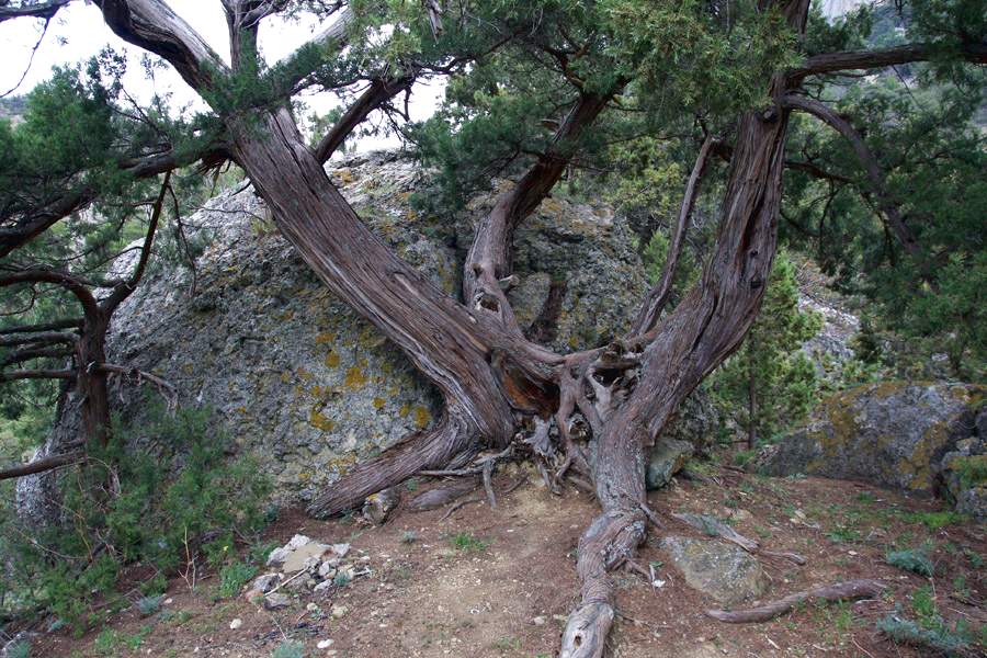
Expeditionary searches of the Commonwealth "Geoshushmor"
On the territory of the Meschera National Park there are amazing
the uniqueness of the objects of megalithic culture, until recently, completely unknown to the scientists-researchers of the megaliths of the Russian Plain. In the process of amateur expeditionary searches, close interaction of a group of enthusiasts of the Commonwealth of Researchers of the Meshchera Territory "Geoshushmor" (Ph.D. Barskov D.P.) with specialists from the Russian Research Institute of Cultural and Natural Heritage named after D.S. Likhachev (Ph.D. Bronnikova V.K.), Institute of Archeology RAS (Sidorov V.V.), National Park "Meschera" (Drozdova Z.N.), Historical and Art Museum of the city of Gus-Khrustalny (Skulov N .I.) On the study of megaliths and boulders found in the park. In total, members of the Geoshushmor Commonwealth (Shushmor land) during the 2008-2012 expeditions across Meshchera in the adjacent territories of the Vladimir, Moscow and Ryazan regions discovered and investigated dozens of stone objects that can be classified as unique monuments of history and archeology. These include individual revered stones (tracers, calyxes, boundary and border boulders), stone sanctuaries and fragments of pagan temples (megaliths with petroglyphs, megalithic structures). All of them can rightfully be classified as objects of natural and cultural heritage. The main purpose of the search was to determine the location of the mysterious stone
hemispheres in the mysterious zone "Shushmore". Until recently, there was a widespread opinion that in this land of ruinous swamps and impassable forest jungles, in principle, there can be no megalithic structures, especially similar to the one that a local old-timer told the famous Shatura local historian N.N. Akimov in the middle of the last century and connoisseur of local tracts. We are talking about the same mound (hemisphere) with a diameter of six meters and a height of three meters, built of stones in a mysterious tract - the mysterious Shushmore, which for the past ten to fifteen years has been unsuccessfully trying to find some groups of enthusiastic romanticists.
Meschera, due to its geographical location in ancient times, was in some isolation from the centers of Slavic culture of North-Eastern and Southern Russia, therefore, on its territory, a "relict oasis" of the languages of the peoples who once lived here has survived. Endless forests, vast swamps, countless rivers and lakes, miraculously preserved almost untouched from destructive economic activity, the area of flora and fauna have fixed and brought to our time the area of placement of ancient geographical names. Some of Meshchera's paleotoponyms can be explained from the position of the Finno-Ugric language group. Meshchera hydronyms with the ending ur, orr or ul, as a rule, are associated with water, river, lake or rain: Vincur, Dandur, Mokshur, Ninor, Nuxor, Sentur, Shestor, Chashchur - these are all tributaries of the Gus and Polya rivers (Tsepkov A. AND.).
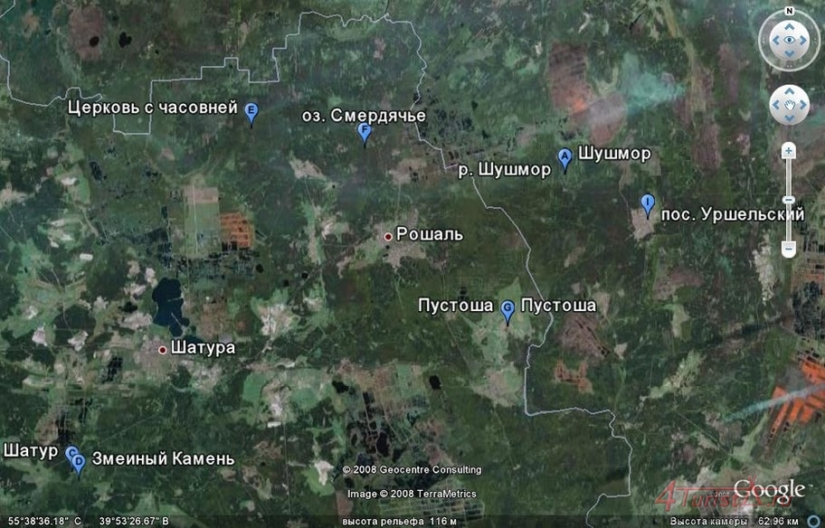
A separate “mesmerizing” word is the name of the reserved Meshchera river Shushmor, which gave the name of the anomalous zone “Shushmor”, known far beyond its borders. This zone is located in the adjacent territories of the Gus-Khrustalny and Sobinsky districts of the Vladimir region near the border with the Shatursky district of the Moscow region. In the north, the border of the zone runs along the line of the Bolshoy and Malye Ostrova villages - Shuvalikha, Pushnino; in the east is the Buzha River and the Wolf Marshes; in the west - Baksheevsky swamps and peat quarries; in the south, the border is the Vyunitsa river, the Bibiki and Gorodok tracts.
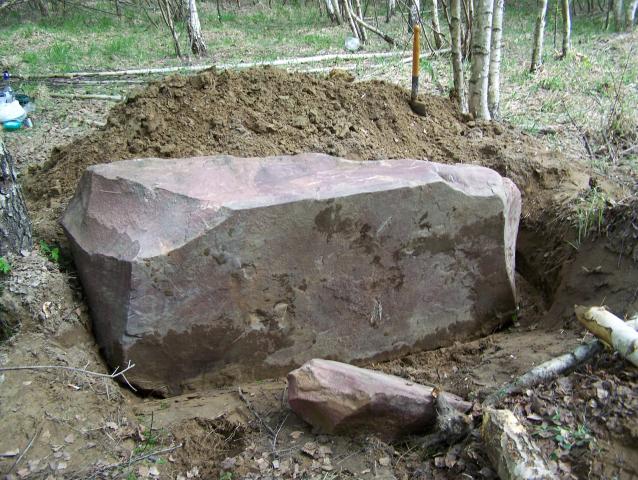
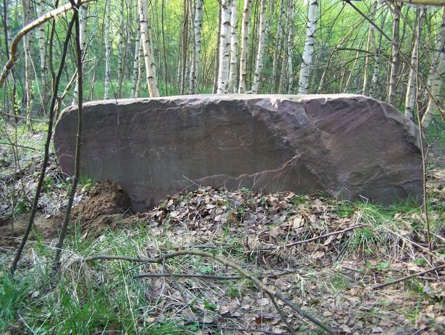
The first expedition of the Commonwealth "Geoshushmor" (2008) carried out a search for megaliths in the area of the conditional geographic triangle - the villages of Turovo, Bolshoi and Malye Ostrov, Sobinsky region. Among the many discovered accumulations of stones, a unique object of this remote corner of Meshchera is the megalith "Fate" in the form of a prism with three cut edges and impressive dimensions (length 2.2 m; width 1.0 m; height 0.9 m). According to the results of laboratory analysis of the selected sample, it was found that the megalith "Fate" is a crimson feldspar and is an aluminosilicate. On the territory of Russia, such feldspars are most often found on the Kola Peninsula and in Karelia, and abroad - in Scandinavia, which confirms the "glacial origin" of this megalith. Distinctive features of the stone "Destiny" are three smooth (polished) edges with sharp edges located at right angles, as well as rock paintings, among which the ancient artist clearly depicts the "Head of a moose". This testifies to the "man-made" period in the history of this megalith, which, apparently, was the central element (menhir) of the circular megalithic structure. This version is supported by another stone of impressive size, which is located 50 meters south of the "Destiny" and, like an iceberg, its main part is underground ...
Megaliths of the Shushmor tract
This mysterious natural boundary is located in the basin of the Shushmor river, which originates in the Volchye Marshes, flows through rugged places with a swampy floodplain and flows into Vyunitsa at the very border with the Baksheevsky bogs. As a rule, the modern population of Meshchera is not able to reliably explain the origin and semantic meaning of the names of local tracts and the overwhelming majority of geographical objects. All these toponyms are "clouded" by the distance of centuries, but with a careful analysis of the ancient languages, one can "read" their semantic meaning. If it is impossible to reveal the meaning of the mysterious word through the modern Russian language, then its foundations should be sought in two closely related languages: Sanskrit and (or) Old Russian. In Sanskrit, "shush" means "six." For a remote swampy area, this name is more than appropriate (Chistyakov N.D.).
Shushmor tract plan
According to the results of the exploration expedition (2009) to the "Shushmor" search zone during 4 hiking routes with a total length of about forty kilometers, the following was established:
- the source of the Shushmor river is located in the western part of the Volch'i Bolota tract with coordinates: SSh 55 deg 43 min 18.1 sec; VD 40 degrees 10 min 21.4 sec; The wolf bogs are the watershed between the flows of the Pol (flows to the south) and the Polya (flows to the north); the Shushmor River flows from east to west (in the opposite direction of the Oka and Klyazma rivers);
No boulders or megaliths were found on the territory of the Volch'i Bolota tract and in the upper reaches of the Shushmor River;
Wolf swamps
- on the right bank of the middle reaches of the Shushmor river, with the help of guides from among the workers of the NP "Meschera" (VN Zheltukhin), an accumulation of more than 10 separately located boulders and large stones was recorded.
The accumulation of stones and boulders in the Shushmor tract testified in favor of the further continuation of the intensive search for the mysterious stone hemisphere in this area.
According to the program of further prospecting and research works of the expedition (2010), approved by the management of NP Meschera, accompanied by park workers, routes were made through the territories of the Shushmor, Gushchina Guard, Rogovskaya Guard, Bibiki tracts. Based on the results of search studies of 4 foot and road routes with a total length of about one hundred kilometers, the following was established:
The Shushmor tract is located in quarter 39 of the Oktyabrsky forestry in the middle reaches of the Shushmor river; the place of intersection of the road "Bam" of the river bed is determined by the coordinates: SSh 55 deg 42 min 57.0 sec; VD 40 deg 05 min 89.8 sec;
The center of the Shushmor tract is a sandy hillock (island) to the left of the Bam embankment road (Urshelsky village - Shuvalikha village), on the edge of which there is a spring, in the area of a branch of the old forest road in the Gushchina Strazha tract with coordinates: SS 55 degrees 42 min 43.0 sec; VD 40 deg 05 min 38.0 sec;
More than ten stones, boulders and megaliths are concentrated along the forest roads encircling the sandy hillock; the largest among them are the boulders "Karavai", "Layered pie", "Polosatik" (cup), as well as the megaliths "Glyba", "Brother" and "Shushmor";
Along the road to "Gushchina Guard", four boulders-megaliths, which are landmarks or road signs, are registered and plotted on the plan;
All recorded boulders and megaliths are located on the sides of the preserved fragments of ancient roads intersecting in the Shushmor tract: Ryazan - Rostov Veliky and Kolomna - Vladimir (from the village of Vlasovo on the old Vladimir road through the "Krestov Brod" on the Voimega river - the right tributary of the river Fields).
Thus, in the search zone "Shushmor" and the surrounding tracts, traces of bygone times are still preserved in the form of the "stone annals of Meshchera" severely damaged by natural and historical cataclysms, which is a direct echo of the original culture of the legendary Hyperborea - the fundamental principle of the "Slavic civilization". In the course of scientific expeditions (Demin V.N.) on the Kola Peninsula, its participants managed to make amazing discoveries - pyramids several tens of meters high from soil and cone-shaped boulders with internal cavities. Their functional purpose is quite accurate observatories that allow you to follow the starry sky. The age of this mysterious observatory is ten thousand years, that is, twice as old as the Egyptian pyramids!
It should be assumed that the mysterious stone hemisphere is an ancient pyramid - an observatory that has lost its original geometric shape over the past millennia and has turned from a "cone" into a "hemisphere". To confirm this very bold hypothesis put forward by members of the Geoshushmor Research Community of the Meshchera Territory, expeditionary searches for the mysterious object must be continued with the involvement of the material and human resources of the Meschera NP.
Anomalous zone "Shushmore"
Megalith "Lump"
The anomaly of the "Shushmore" zone is characterized by an increased background of the strength of the Earth's magnetic field, which, according to the results of magnetometric control, exceeds the natural background by 20% - 25%. During the expedition on May 2, 2010 in the Shushmor tract from 23.30 to 24.00, its participants visually recorded the glow of the atmosphere over the floodplain of the Shushmor river, which was accompanied by amplitude bursts of the Earth's magnetic field strength with an excess of the natural background by 1.5 - 2.0 times ...
Members of the Geoshushmor Commonwealth in the course of expeditionary searches in 2009 - 2010 also managed to record unusual phenomena, which indirectly testify to the anomalousness of the processes taking place in the Shushmor zone.
Firstly, these are lightning discharges of the "Catatumbo lightning" type, which appeared eight times in a row at short intervals of several seconds in the direction of the same place just before the onset of a storm thunderstorm on the evening of June 13, 2009. These lightning bolts were low-flying "pulsating glowing electrical flashes." The phenomenon observed from the base camp by several members of the expedition (Barskov D.P., Goncharov Yu.V., etc.) appeared in the direction of the "Wolf Swamps" tract to the source of the Shushmor river. Lightning did not start in the clouds
Megalith "Shushmore"
and much lower - as if over the tops of the trees of the neighboring forest. At the same time, lightning went to the ground not as usual, in a zigzag, but strictly along a steep trajectory, almost vertically. The power of lightning was barely enough to only weakly illuminate the low-flying thunderclouds close to it, that is, the origin of flares occurred at a distance of no more than one kilometer from the base camp of the expedition.
Secondly, returning to the base camp after exhausting many kilometers of routes in the heat through the impassable forest wilderness and the Wolf Marshes, the members of the expedition recovered their strength very quickly. Some of the participants, according to the observation of the expeditionary doctor (Yu.V. Goncharov), stabilized their blood pressure, while others no longer felt headaches and "whistling" in their ears, which they experienced even during the period of home gathering on the expedition.
Most likely, according to the ancient rules of sacralization of space, the Shushmor tract may turn out to be such a balanced zone for “clean energy” that, in its turn, in terms of its practical use, it may open up unique opportunities of its territory for balneological (resort) treatment of patients in the future. In particular, again such diseases as hypertension and cardiovascular insufficiency (Goncharov Yu.V.).
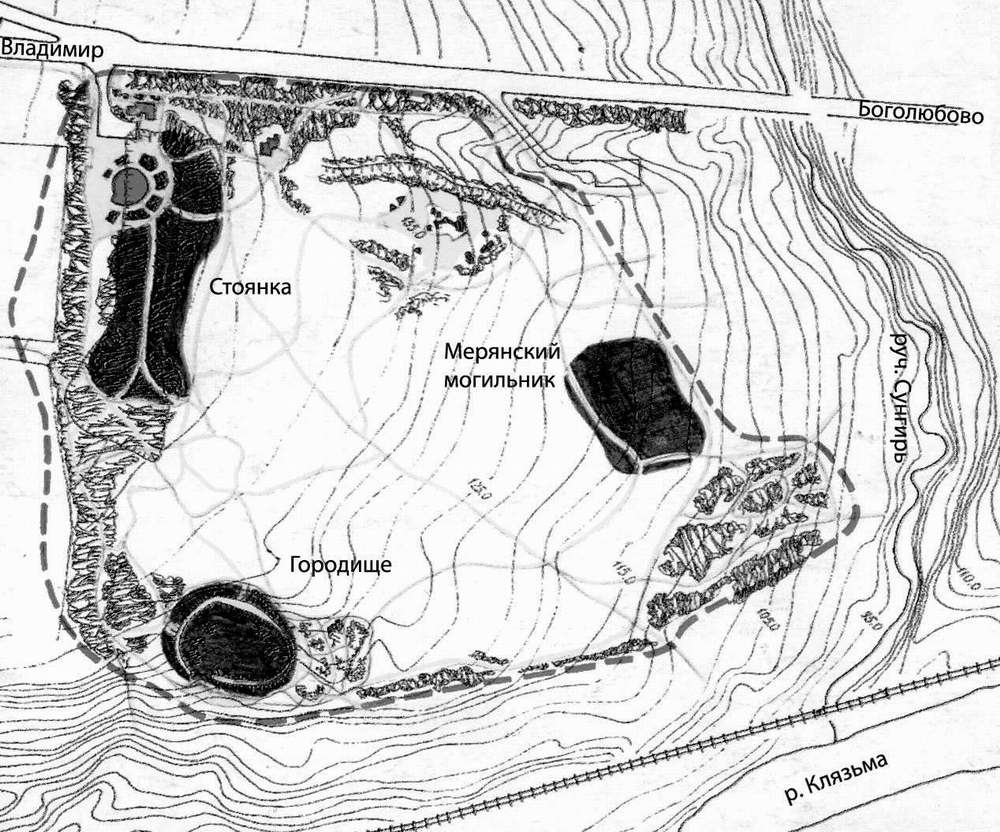
Megalithic complex in the tract "Rogovskaya Guard"
Of considerable interest for further historical and archaeological research is the megalithic complex in the Rogovskaya Guard tract, explored during the expeditions of the Geoshushmor Commonwealth (2010; 2012). The complex occupies a significant part of the territory of the tract, on the site of which a forest gatehouse was located until the middle of the 20th century (in the old days they were called "guards" by the names of those foresters-rangers who lived in them with their families). Rogovskaya guard (gatehouse) was located near the fork of the ancient road from Ryazan to Vladimir and Novgorod the Great. Half a kilometer to the north, behind a stream, the road bifurcated ("you will go to the left ...", "you will go to the right ...") and one left - to the village of Tikhonovo and further through the tract "Shushmor" went to Osovets and Rostov Veliky, and the other - to the village of Erleks and to Vladimir.
The layout of the boulders of the "Zapolsky sanctuary"
The complex includes the central element of a megalithic structure of four powerful black granite boulders located at the corners of the square, and to the south of it there is a whole placer of stones (including huge ones) of black granite and pinkish-gray very dense quartz sandstone or feldspar. They are located on a hill - a dune, but possibly on a sandy ridge with an elevation of approximately 140 m in pine plantations 60 years old. To the north of the hill, in the lowland, there are long-lived birches with a trunk diameter of 140-145 cm, bordering a meadow. It is possible that this hill represents a burial mound, therefore archaeological research of the area is necessary.
The stones and boulders of this megalithic complex received the author's name "Zapolskoye Sanctuary", since it is located three kilometers east of the Pol River. Geographic coordinates of the unique complex: SSh 55 deg 31 min 10.0 sec; VD 40 degrees 16 min 10.0 sec.
The megaliths of the central element of the structure, consisting of 4 boulders, are an indisputable analogue of a proto-temple sanctuary. In this capacity, the dolmen structure acts, which is fixed by the four corners of the entire structure - only the covering plate (demand) is missing. Apparently, the stone slab was lost in later times (it could have been broken into pieces for construction purposes). In the upper part of all 4 megaliths of the central element, artificial ledges have been preserved to support the covering slab (the reconstruction of the megalithic structure was carried out by the artist Valentin Barskov). The stone structures of the central element of the sanctuary can be rightfully called “dolmen”.
Boulder with petroglyph "Elk's head"
Of course, it is only a kind of echo of the North Caucasian dolmens with their perfect fit of stone supports and slabs to each other. The megaliths of the Zapolsky Sanctuary are more reminiscent of analogs of the Belozersk dolmens (Vologda Oblast), in which a horizontal slab freely rests on stones of arbitrary shape (after all, unlike the foothills of the Caucasus, within the Russian Plain there is an incomparably smaller selection of stones).
The boulders are covered with several types of lichens. The most abundant species is Lepraria incana, covering with a continuous bluish-glaucous
bloom on the lower parts of the stones. This species usually grows in the bases of tree trunks, that is, it has moved from them to stones. Other species are less abundant. At the same time, some of them also passed from the bark of trees, others are typical epilites, that is, the original inhabitants of stones. 4 - 5 species of lichens are new for the NP "Meschera", but in order to clarify the species of some lichens, it will be necessary to study them in the laboratory in the future. In general, it is safe to say that the stones have been in this position for a very long time. Firstly, by the abundance of lichens, and secondly, by the layer of humus, which has managed to form on their surface and become covered with mosses. If there was a plate on them, then it disappeared a very long time ago, otherwise nothing would have had time to grow. Boulders, including those lying in the district, of different species composition, at least three breeds, that is, they were brought here from different places (Zhdanov I.S.).
"Zapolskoye sanctuary" dolmen type (reconstruction
member of the expedition, artist V.D. Barskov)
The pre-Christian origin of the megalithic complex "Zapolskoe sanctuary" is beyond doubt. Later, as usual, there was a combination of ancient beliefs and their later interpretations in the form of a pagan temple. As you know, there are many options for sanctuaries and temples, although the same principle was observed everywhere - a circle. They were built on hills, near streams, along river banks on prominent promontories, at the intersection of roads, etc. One of these temples could have appeared on the territory of the megalithic structure "Zapolskoye Sanctuary". Of course, there is no clearly defined circle of stones - they are scattered around or lost forever. But what has survived and has survived to this day, due to the fact that the ancient road ceased to fully function a century ago, and new highways ran far from these places, is a unique monument of ancient culture on the territory of the Meschera NP.
Megalith with a flat base
Of course, this unique object will become the subject of unremitting interest of archaeologists and researchers, local lore explorers and participants in nature tourism. It is necessary to carry out a mineralogical examination, selective excavations.
Stones with "cups" carved into them seem to be very interesting. It is known that the cults of trace stones and cup stones coexisted in the megalithic culture side by side (or in parallel). Calyx stones are stones with small, usually
with a diameter or length of several centimeters in cup-shaped indentations.
Both the geometry of the "cups" and their number can be very different. There are known stones with "cups", which have a strictly cylindrical shape, and with "cups", which are shallow holes, as if pressed by a finger (such stones are sometimes called "fingers"). The number of "cups" on a stone can vary from one or two to hundreds or even more (Platov A.V.).
Archeologically, cup stones are most often tied to burial structures. It has been reliably established that in deep antiquity, many "cups"
Megalithic complex (reconstruction by V.D. Barskov)
served as "altars". There are cup-stones in megalithic sanctuaries of one type or another, that is, they are part of cult complexes.
Depressions in the sacred stones (respectively, "calyxes" and "tracers") can be both man-made and completely natural. Often it is not possible to find out reliably. Tradition stones and cup stones are associated in the sacred Tradition with healing magic: rainwater,
Megalith-cup "Stripe"
gathering in the depressions, was revered as healing ... Both with the "investigators" and with the "cups" are often associated legends in which either "evil spirits" act (for example, "Devil's Trail", "Devil's Stone"), or, on the contrary, divine characters ("Perunov stone", "God's stone"). Scientists suggest that the cults of cup stones occupied an important place in the structure of almost any traditional ritual - the act of sacrifice. It is known that in the Indo-European Tradition, in which the stone has such a great sacred significance, it is a stone that acts as an altar, most often a flat megalith (altar).
As a rule, such a stone slab is a kind of altar or altar, in the "bowl" of which the sacrifice was poured or laid (honey, beer, blood; meat, agricultural products or "gifts of the forest", etc.).
Main results and prospects for further research
1. The study of sacred and cult stones on the territory of the Meschera National Park has no history yet. Until recently, there was only fragmentary information about landscape clusters of boulders or individual revered stones. At the same time, the originality of the Meshchera landscapes was not taken into account, in which centuries-old traditions of veneration of cult stones were formed and the megalithic culture of this geographical region was formed.
Meshchersky "Blue-stone"
2. As part of the megalithic complex "Zapolskoe sanctuary", in the tract "Shushmor" and along the road to the "Gushchina Guard" are concentrated placers of rather large rough stones. Along with the established purpose of the "Zapolsky sanctuary", it should also be assumed that stones with both natural depressions (the Polosatik boulder in the Shushmor tract) and artificially carved depressions (a roadside boulder at Gushchina Guard ", Boulder" Zapolsky sanctuary "). The “Brother” megalith with a flat inclined surface facing north (the “Shushmor” tract) could well have been used as an altar.
3. Undoubtedly, all cup-stones found on the territory of the Meshchera NP require special research for scientific confirmation of their purpose. This applies equally to the rest of the found megaliths. The stone structure of the central element of the sanctuary (dolmen) is one of the unique objects of megalithic culture on the territory of the Meshchera NP and has already become the subject of tireless interest of archaeologists and researchers and local lore explorers. It is necessary to carry out a mineralogical examination, selective excavations. It is necessary to ensure the safety of this unique object and urgently, on the basis of the Federal Law on Archaeological Monuments, the megalithic complex "Zapolskoye Sanctuary" should be transferred to the category of "Interesting place".
4.The number of objects of megalithic culture should include boulders on the outskirts of the village
Megalith "Loaf"
Zabolotye, an accumulation of stones near the village of Savvinskaya and "Chaslitsky megaliths" in the village of Chaslitsy (ancestral monument near the estate of MS Anisimov). Natural tourism routes can also be laid to these sites.
5. It is imperative to develop a geographical map of ancient roads on the territory of the NP "Meschera". Such a map can help researchers identify the potential habitats of people of the most ancient megalithic culture and, at the same time, reveal sacred patterns when studying the structure of the discovered megalithic sanctuaries. This map (let's call it "road") will help to understand the archaeological mysteries in the park and will lay a truly scientific basis for the study of "strangely located" and "unlike anything" megaliths and megalithic structures. The "road" map will serve for a more accurate laying of routes to objects of "nature tourism", as well as the creation of tourist bases and health centers in the future.
6. It is necessary to continue monitoring (long-term observations) of changes in the strength of the Earth's magnetic field in the anomalous zone "Shushmor" in order to establish the places of "Force". As you know, this is how the sacred places of worship for the forces of Nature are called, it was there that megalithic complexes were built in time immemorial. Our ancestors in places of geohectogenic zones (faults in the earth's crust) tried to use the "Power" of the Earth for their own good. The ancient rules of sacralization of space in the locations of megalithic complexes by modern scientists in relation to the "sacred areas" of Meshchera can be interpreted as follows:
Here, Nature itself balances the energy of Yan (the male power of hills - manes and islands) with the energy of Yin (the female power of swampy lowlands and valleys), which in itself can give rise to pure energy.
VISITING RULES
If you want to visit our National Park, follow the established rules and do not harm the nature around you!
You can only move in the park along specially laid routes, paths and paths;
To visit the park along one of the developed routes, you need to buy a voucher;
The excursion group is accompanied by an instructor throughout the entire stay in the park, excursions are conducted by a guide;
Camping, setting up tents and making a fire is allowed only in specially designated places;
Gathering berries and mushrooms in the park is possible with a permit. Remember that the collection of wild plants, medicinal raw materials is strictly prohibited !;
Hunting and fishing in inland waters with special permits issued by the park administration;
Do not destroy what is created for your pleasant stay in the park;
Don't leave trash in the park after your stay!
____________________________________________________________________________________________
SOURCE OF INFORMATION AND PHOTOS:
Team nomad
http://park-meshera.ru
http://www.parkmeshera.ru
http://oopt.info/index.php?oopt=1128
Natural Monuments of the Russian Federation
Surface water resources of the USSR: Hydrological study. T. 10. / Ed. V.P. Shaban. - L .: Gidrometeoizdat, 1966 .-- 528 p.
Tourist water encyclopedia
Encyclopedic Dictionary of Brockhaus and Efron: In 86 volumes (82 volumes and 4 additional). - SPb., 1890-1907.
| The attachment | The size |
|---|---|
| 122.13 KB | |
| 199.48 KB | |
| 147.48 KB | |
| 109.38 KB | |
| 79.7 KB | |
| 171.33 KB | |
| 88.83 KB | |
| 395.72 KB | |
| 217.68 KB | |
| 104.31 KB | |
| 269.69 KB |


