The Caspian Sea is the largest closed body of water on the planet Earth, located on the continent of Eurasia - in the border territories of the states of Russia, Kazakhstan, Turkmenistan, Iran and Azerbaijan. In fact, it is a giant lake left after the disappearance of the ancient Tethys ocean. Nevertheless, there is every reason to consider it as an independent sea (this is indicated by salinity, a large area and decent depth, a bottom from the oceanic crust, and other signs). In terms of maximum depth, it is the third among closed bodies of water - after lakes Baikal and Tanganyika. In the northern part of the Caspian Sea (a few kilometers from the northern coast - parallel to it) there is a geographical border between Europe and Asia.
- Other names: throughout the history of mankind, the Caspian Sea had about 70 different names among different peoples. The most famous of them: Khvalynskoe or Khvalisskoe (took place during Ancient Rus, originated from the name of the people praises who lived in the Northern Caspian Sea and traded with the Russians), Girkanskoe or Dzhurdzhanskoe (derived from the alternative names of the city of Gorgan, located in Iran), Khazar, Abeskunskoe (according to the name of the island and the city in the Kura delta - now flooded), Saraisk, Derbent, Sihai ...
- Origin of name: according to one hypothesis, the Caspian Sea received its modern and most ancient name from a tribe of nomadic horse breeders Kaspiev who lived in the 1st millennium BC on the southwestern coast.
Morphometry
- Drainage area: 3,626,000 km².
- Mirror area: 371,000 km².
- Length coastline: 7,000 km
- Volume: 78 200 km³.
- Average depth: 208 m.
- Maximum depth: 1,025 m.
Hydrology
- The presence of a constant flow: no, drainless.
- Inflows:, Ural, Emba, Atrek, Gorgan, Heraz, Sefidrud, Astarchay, Kura, Pirsagat, Kusarchay, Samur, Rubas, Darvagchay, Uluchay, Shuraozen, Sulak, Terek, Kuma.
- Bottom: very diverse. At shallow depths, sandy soil with an admixture of shells is common, in deep-water places it is silty. Pebble and rocky places can be found in the coastal strip (especially where mountain ranges adjoin the sea). In the estuarine areas, the underwater soil consists of river sediments. The Kara-Bogaz-Gol bay is notable for the fact that its bottom is a thick layer of mineral salts.
Chemical composition
- Water: brackish.
- Salinity: 13 g / l.
- Transparency: 15 m.
Geography

Rice. 1. Map of the Caspian Sea Basin.
- Coordinates: 41 ° 59′02 ″ s. sh., 51 ° 03'52 ″ in. etc.
- Height above sea level:-28 m.
- Coastal landscape: due to the fact that the coastline of the Caspian Sea is very long, and it itself is located in different geographic zones, the coastal landscape is diverse. In the northern part of the reservoir, the banks are low, swampy, in places of the deltas of large rivers cut by numerous channels. The eastern shores are mostly limestone - desert or semi-desert. Western and south coast adjoin mountain ranges. The most indented coastline is observed in the west - in the area of the Apsheron Peninsula, as well as in the east - in the area of the Kazakh and Kara-Bogaz-Gol bays.
- Settlements on the banks:
- Russia: Astrakhan, Derbent, Kaspiysk, Makhachkala, Olya.
- Kazakhstan: Aktau, Atyrau, Kuryk, Sogandyk, Bautino.
- Turkmenistan: Ekerem, Karabogaz, Turkmenbashi, Khazar.
- Iran: Astara, Balboser, Bender-Torkemen, Bender-Anzeli, Neka, Chalus.
- Azerbaijan: Alat, Astara, Baku, Dubendi, Lankaran, Sangachaly, Sumgayit.
Ecology
The ecological situation in the Caspian Sea is far from ideal. Practically all large rivers flowing into it are polluted by wastewater from industrial enterprises located upstream. This could not but affect the presence of pollutants in the waters and bottom sediments of the Caspian Sea - over the past half century, their concentration has increased markedly, and the content of some heavy metals has already exceeded the permissible limits.
In addition, the waters of the Caspian Sea are constantly polluted by domestic wastewater from coastal cities, as well as during oil production on the continental shelf, and during its transportation.
Fishing in the Caspian Sea
- Fish species:
- Artificial settlement: not all of the above fish species in the Caspian Sea are indigenous. About 4 dozen species were caught by accident (for example, through the channels from the Black and Baltic seas), or were deliberately inhabited by humans. An example is mullet. Three Black Sea species of these fish - striped mullet, ostronos and singil - were released in the first half of the 20th century. Loban did not take root, but the ostronos with the singil have successfully acclimatized, and by now they have settled practically throughout the entire water area of the Caspian, having formed several commercial herds. At the same time, fish feed faster than in the Black Sea, and reach larger sizes. In the second half of the last century (since 1962), attempts were also made to settle in the Caspian Sea such Far Eastern salmon fishes as pink salmon and chum salmon. In total, several billion fry of these fish were released into the sea for 5 years. The pink salmon did not survive in the new habitat, the chum salmon, on the contrary, successfully took root and even began to spawn in the rivers flowing into the sea. However, she could not reproduce in sufficient numbers and gradually disappeared. So far, there are no favorable conditions for its full-fledged natural reproduction (there are very few places where spawning and development of fry could successfully occur). To ensure them, reclamation of rivers is needed, otherwise, without human help (artificial sampling of eggs and its incubation), the fish will not be able to maintain their numbers.


Fishing spots
In fact, fishing is possible anywhere along the coast of the Caspian Sea, which can be reached by land or water. What species of fish will be caught at the same time depends on local conditions, but to a greater extent on whether rivers flow here. As a rule, in places where estuaries and deltas are located (especially large watercourses), the water in the sea is strongly desalinated, therefore freshwater fish (carp, catfish, bream, etc.) usually prevail in catches, and species characteristic of flowing rivers (barbel, shemaya). Of the marine species in desalinated areas, those for which salinity does not matter (mullet, some of the gobies) are caught. In certain periods of the year, semi-anadromous and anadromous species can be found here, feeding in the sea, and spawning into rivers (sturgeon, some of herring, Caspian salmon). In places where there are no rivers flowing into it, freshwater species are found in slightly smaller numbers, but at the same time marine fish appear, usually avoiding desalinated areas (for example, sea pike perch). Far from the coast, fish are caught, preferring salt water, and deep sea views.
In total, there are 9 places that are interesting in terms of fishing:
- North Shore (RF)- this site is located on the northern coast of the Russian Federation (from the Volga delta to the Kizlyar Bay). Its main features are insignificant salinity of water (the lowest in the Caspian Sea), shallow depth, the presence of multiple shoals, islands, highly developed aquatic vegetation. In addition to the Volga delta with its numerous channels, bays and eriks, it also includes the estuarine seashore, called the Caspian peals. These places are popular with Russian fishermen, and for good reason: the conditions for fish are very favorable here, and there is also a good food base. The ichthyofauna in these parts may not be distinguished by the richness of species, but it is distinguished by its multiplicity, and its individual representatives reach very considerable sizes. Typically, the main catches are freshwater fish typical for the Volga basin. Most often caught: perch, pike perch, roach (more precisely, its varieties, called roach and ram), rudd, asp, sabrefish, bream, goldfish, carp, catfish, pike. Bersh, silver bream, white-eyed, blue bream are somewhat less common. Representatives of sturgeon (sturgeon, stellate sturgeon, beluga, etc.), salmon (nelma, brown trout - Caspian salmon) are also found in these places, but their catch is prohibited.
- Northwest coast (RF)- this section covers the west coast Russian Federation(from the Kizlyar Bay to Makhachkala). The rivers Kuma, Terek and Sulak flow here - they carry their waters both along natural channels and artificial canals. There are bays in this area, some of which are quite large (Kizlyarsky, Agrakhansky). The sea in these places is shallow. Freshwater fish predominate in the catches: pike, perch, carp, catfish, rudd, bream, barbel, etc.
- West Bank (RF)- from Makhachkala to the border of the Russian Federation with Azerbaijan. A site where mountain ranges adjoin the sea. The salinity of the water here is slightly higher than in the previous places, therefore, in the catches of fishermen, marine species are more common (sea pike perch, mullet, herring). However, freshwater fish are by no means uncommon.
- West Bank (Azerbaijan)- from the border of the Russian Federation with Azerbaijan along the Absheron Peninsula. Continuation of the site, where mountain ranges adjoin the sea. Fishing here is even more like a typical sea one, thanks to such fish as ostronos and singil (mullet) and several species of gobies, which are also caught here. In addition to them, there are kutum, herring, and some typically freshwater species, for example, the carp.
- Southwest coast (Azerbaijan)- from the Absheron Peninsula to the border of Azerbaijan with Iran. Most of this site is occupied by the Kura River delta. The same fish species that were listed in the previous paragraph are caught here, but freshwater fish are more often caught.
- North coast (Kazakhstan)- this section covers the northern coast of Kazakhstan. The Ural delta and state reserve"Akzhaiyk", therefore, fishing directly in the river delta and in some adjacent water area is prohibited. Fishing is possible only outside the reserve - upstream of the delta, or in the sea - at some distance from it. Fishing near the Ural delta has much in common with fishing at the confluence of the Volga - almost the same species of fish are found here.
- North-east coast (Kazakhstan)- from the mouth of the Emba to Cape Tyub-Karagan. In contrast to the northern part of the sea, where the water is greatly diluted by the large rivers flowing into it, its salinity somewhat increases here, therefore those species of fish appear that avoid freshened areas, for example, sea pike perch, which is caught in the Dead Kultuk Bay. Other representatives of the marine fauna are also often found in the catches.
- East coast (Kazakhstan, Turkmenistan)- from Cape Tyub-Karagan to the border of Turkmenistan and Iran. Differs in almost complete absence of flowing rivers. The salinity of the water is at its maximum here. Of the fish in these places, marine species predominate, the main catch is mullet, sea pike perch and gobies.
- South Bank (Iran)- covers the southern coast of the Caspian. Along the entire length of this section, the Elburs mountain range adjoins the sea. Many rivers flow here, most of which are represented by small streams, there are also several medium and one large river. Among fish, in addition to marine species, there are also some freshwater, as well as semi-anadromous and anadromous species, for example, sturgeon.
Fishing features
The most popular and catchy amateur tackle, which is used on the Caspian coast, is a heavy spinning rod converted into a "sea donkey". Usually it is equipped with a strong reel, on which a rather thick line (0.3 mm and more) is wound. The thickness of the line is determined not so much by the size of the fish as by the mass of a rather heavy sinker, which is necessary for ultra-long casting (in the Caspian it is generally believed that the further from the coast the casting point is, the better). After the sinker, there is a thinner line - with several leads. Shrimps and amphipods that live in coastal thickets of algae are used as a bait - if you intend to fish for sea fish, or an ordinary bait like a worm, May beetle larvae and others - if freshwater species are found in the fishing area.
The Caspian Sea is simultaneously located on the territory of 5 countries, including not only Russia and Kazakhstan, but also Turkmenistan, Iran and Azerbaijan. This is the world's largest enclosed body of water, which has long been characteristic and known to everyone as the sea. But the question is why the Caspian Sea is called the sea, because in reality it is a lake? And in this situation, we will figure it out today.
Why the Caspian Sea is called the sea
Despite the fact that this reservoir is a lake, it is often called the sea. A significant part of people do not even know that this is a lake. This can be explained very simply, because even at one glance at this reservoir, depicted on the maps, its scale is striking, which is characteristic mainly of the seas. A lake that washes the borders of five countries at once is something unthinkable.
Yes, this is something unthinkable, but it is so, because this is the largest, the largest closed lake worldwide. And its size is the short and first reason why it is often called the sea. In addition, the fact that there are slightly more than 50 islands on its territory also plays in favor of the fact that this lake can be called a sea. It is noteworthy that some of them are not just average in scale, but truly large in size, the area of which, imagine, reaches 350 square kilometers.
Why is the Caspian Sea called a lake
As for the true name of this reservoir, it belongs to lakes for a number of reasons. You can summarize them in a short list below:
- The lake bed is outlined by the earth's crust, which has an oceanic type;
- Despite its size and similarity to full-fledged seas, the lake has practically fresh, slightly salted water;
- Almost any sea is part of the world's oceans, and Caspian lake, due to its geographical location, has no access to the open ocean.
It is also noteworthy that the status of the lake near the Caspian Sea is also confirmed by the fact that the UN international regime does not apply to its waters, and the water area of the lake is divided between the adjacent states in a different way than in the case of the seas.
Interestingly, the Caspian Lake is often called not only the Caspian Sea, but also the Caspian. And now, after reading the text of this article, you will probably know that, despite its similarity to the sea, the presence of many properties and characteristics inherent only to the seas, the Caspian is still a lake, and this is a fact.
Caspian Sea Caspian Sea (Greek Káspion pélagos, Latin Caspium Mare), the world's largest enclosed body of water on the territory of the USSR (RSFSR, Kazakh SSR, Turkmen SSR, Azerbaijan SSR) and Iran. It is often regarded as the greatest lake on the Earth, which is inaccurate, since in terms of its size, the nature of the processes, and the history of the development of the K. m. It is a sea. It got its name from the ancient tribes of the Caspians (see Caspian), who lived in the eastern part of the Caucasus. Other historical names -
Girkanskoe, Khvalynskoe (Khvalisskoe), Khazarskoe - also after the names of the ancient peoples who lived on its banks. Physical and geographical sketch. General information. K. m. Stretched from north to south by almost 1200 km, average width 320 km, the length of the coastline is about 7 thous. km(of which more than 6 thousand. km within the USSR). Area about 371 thousand sq. km 2; level at 28.5 m below the level of the World Ocean (1969). Maximum depth 1025 m... In 1929, before a significant decrease in the level of K. m., Its area was 422 thousand sq. M. km 2. The largest bays: in the north - Kizlyarsky, Komsomolets; in the east - Mangyshlaksky, Kenderli, Kazakh, Kara-Bogaz-Gol, Krasnovodsky; in the west - Agrakhansky, Baku Bay; in the south there are shallow lagoons. There are up to 50 islands, mostly small (total area about 350 km 2),
the most significant are Kulaly, Tyuleny, Chechen, Artem, Zhiloy, Ogurchinsky. The most significant rivers flow into the northern part of the sea - the Volga, Emba, Ural, Terek, the total annual flow of which is about 88% of the total river flow into the Caspian. The large rivers Sulak, Samur, Kura and a number of smaller ones (about 7% of the flow) flow into the western coast. The remaining 5% of the runoff comes from the rivers of the Iranian coast (Gorgan, Heraz, Sefidrud). On east coast, including the coast of Kara-Bogaz-Gol, there is not a single permanent watercourse. The shores. The shores of the northern part of the Caspian are low-lying and very sloping, characterized by a wide development of drylands, which are formed as a result of surge phenomena; here are also developed delta shores (deltas of the Volga, Ural, Terek). In general, the shores of the northern part are growing rapidly, which is facilitated by the drop in sea level, the rapid growth of deltas and the abundant supply of terrigenous material. The western shores of the K. m. Are also mostly accumulative (numerous spits, spits), and some areas on the coasts of Dagestan and the Apsheron Peninsula are abrasive. On the eastern coast of the sea, abrasion shores prevail, developed in limestones that compose the adjacent semi-desert and desert plateaus. There are also accumulative forms: the Karabogaz barrage, which separates the largest gulf of the Caspian from the sea - Kara-Bogaz-Gol, the Krasnovodskaya and Kenderli spits. To the south of the Krasnovodsk Peninsula, accumulative shores predominate. Relief. By the nature of the relief and hydrological features The Caspian Sea is usually subdivided into the North Caspian, the Middle Caspian, and the South Caspian. Northern Caspian (area about 80 thousand sq. km 2) -
the shallowest part of the sea with depths of 4-8 m.
The bottom relief is a weakly wavy accumulative plain with a series of banks and accumulative islands, the so-called Mangyshlak sill, separating the North Caspian from the Middle. Within the Middle Caspian (area about 138 thous. km 2) stand out: Derbent depression (maximum depth 788 m),
shelf and continental slope complicated by underwater landslides and canyons; on the northern, rather gentle slope, relics of ancient river valleys were found. In the south, the basin of the Middle Caspian is separated from the basin South Caspian Absheron rapids, on which there are a number of banks and islands. Depression of the South Caspian (maximum depth 1025 m), which makes up about 1/3 of the sea area, has a narrow shelf near the western and southern (Iranian) coasts, while the shelf is much wider off the eastern coast. The bottom of the depression is a flat abyssal plain. In the northern part of the depression, there are several submarine ridges of northwestern and southeastern strikes. Geological structure and minerals. The northern part of the Caspian Sea is the margin of the Pre-Caspian syneclise of the East European Platform; The Mangyshlak sill is structurally connected with the Hercynian buried Karpinsky rampart on the western coast of the sea and with the Mangyshlak mountains on the east. The bottom of the Middle Caspian has a heterogeneous structure. Its eastern part is a submerged section of the epigercynian Turan platform; The Derbent Basin, as well as the western parts of the shelf and the continental slope, is the foredeep of the geosyncline of the Greater Caucasus. The Absheron sill corresponds to one of the branches of the newest structures that formed on the subsidence of the folded formations of the Greater Caucasus and connects them with the folded structures of the Kopetdag. The South Caspian is characterized by a suboceanic structure of the earth's crust; there is no granite layer. Under the sedimentary layer up to 25 km(which obviously indicates the great antiquity of the South Caspian basin) is overlain by a basalt layer up to 15 km.
Until the Upper Miocene, the Caspian Sea as a sea basin in its geological history was closely connected with the Black Sea. After the Upper Miocene folding, this connection was interrupted, and the sea was transformed into a closed body of water. The connection with the ocean was renewed in the Upper Pliocene, in the Akchagyl age. In the Anthropogen, due to the alternation of glacial and postglacial eras on the East European Plain, the Caspian Sea repeatedly experienced transgressions (Baku, Khazar, and Khvalynskaya) and regressions, traces of which have been preserved in the form of terraces on the sea coast and in the stratigraphy of ancient Caspian deposits. Terrigenous shell sands, shells, oolitic sands are widespread on the shelf; deep-water areas of the bottom are covered with silty and silty sediments with a high content of calcium carbonate. In some areas of the bottom, bedrocks of the Neogene age are exposed. At the bottom of the Kemerovo m there are rich deposits of oil and gas. The Apsheron sill, the Dagestan and Turkmen regions of the sea are oil and gas bearing. Seabed areas adjacent to Mangyshlak, as well as the Mangyshlak sill, are promising for oil and gas. The Gulf of Kara-Bogaz-Gol is the largest deposit of chemical raw materials (in particular, mirabilite). Climate. The main baric centers that determine the atmospheric circulation in the region of the sea are the spur of the Asian maximum in winter and the spurs of the Azores maximum and the South Asian minimum in summer. The characteristic features of the climate are: significant continentality, the predominance of anticyclonic weather conditions, dry winds, severe frosty winters (especially in the northern part), sharp temperature changes throughout the year, and poor precipitation (excluding the southwestern part of the reservoir). On atmospheric fronts, cyclonic activity is developing, which is also an important element of the climate and weather in the Caspian. In the northern and middle parts of the K. m. From October to April, the winds of the eastern points prevail, from May to September, the winds of the northwestern points; in the southern part of the sea, the monsoon nature of the winds is most pronounced. The strongest winds are characteristic of the region of the Absheron Peninsula (Baku Nord, blowing mainly in autumn), the eastern coast of the middle part and the north-western region of the northern part; storms are frequent here, in which the wind speed reaches more than 24 m/sec.
Average long-term air temperature warm months(July - August) over the entire sea is 24-26 ° С, the absolute maximum (up to 44 ° С) is noted on the eastern coast. In the winter months, the temperature varies from -10 ° C in the north to 12 ° C in the south. On average, 200 mm precipitation per year, on the west coast - up to 400 mm,
in the arid east - 90-100 mm,
in the subtropical southwestern part of the coast - up to 1700 mm... Evaporation from most of the sea surface is very high - up to 1000 mm in year; in the eastern part of the South Caspian and in the area of the Absheron Peninsula - up to 1400 mm in year. Hydrological regime. Cyclonic water circulation is dominant in the Mediterranean Sea, which is mainly due to river runoff and prevailing winds. Water masses move from north to south along the western coast of the sea to the Apsheron Peninsula, where the current splits: one branch continues along the western coast, the other crosses the K. m. In the area of the Apsheron threshold and at the eastern coast joins the waters moving to the north. along the eastern coast from the South Caspian. Cyclonic circulation is also observed in the South Caspian, but less pronounced, and between Baku and the mouth of the river. Chickens complicated by local anticyclonic circulation. Unstable wind currents of various directions prevail in the North Caspian. Their speed is usually 10-15 cm/sec, with strong winds coinciding with the direction of currents, the speed can reach 30-40 and even 100 cm/sec... Frequent recurrence of moderate and strong winds causes a large number of days with significant excitement. Maximum observed wave height up to 11 m- in the area of the Absheron threshold. The water temperature in summer on the surface averages 24-26 ° C, in the south - up to 29 ° C, in Krasnovodsk Bay - up to 32 ° C. On the eastern shores, temperatures sometimes drop to 10-12 ° C in July and August. This phenomenon is associated with the surging effect of winds and the rise of deep waters. In winter, significant temperature contrasts are noted: in the north, freezing temperatures (down to -0.5 ° C), in the Middle Caspian Sea 3-7 ° C, and in the Southern Caspian 8-10 ° C. The northern part of the sea usually freezes by 2-3 month., ice thickness reaches 2 m... In the Middle Caspian, separate shallow bays freeze during severe winters. There are frequent cases of intensive breaking of ice by the wind and its drift from the North Caspian to the south along the western coast. In some years, floating ice reaches the area of the Absheron Peninsula and is capable of causing significant damage to hydraulic structures in the sea. The average salinity of the waters is 12.7-12.8 ‰, the maximum (excluding the Kara-Bogaz-Gol Bay) near the eastern shores is up to 13.2 ‰, the minimum in the northwest. - 1-2 ‰. Fluctuations in salinity over the sea area, vertically, and in time are insignificant, and only in the north are they more noticeable due to fluctuations in the Volga runoff. The composition of salts differs from the usual oceanic salt in the high content of sulfates, calcium carbonates, magnesium and, accordingly, in the lower content of chlorides, which is due to the influence of river runoff. Vertical mixing of waters in winter time covers the entire water column in the North Caspian and layer 200-300 m in deep-water areas, in summer and autumn it is limited to the upper layer of 15-30 m... In these seasons, at the lower boundary of the upper well-heated and mixed layer (15-30 m) an intense layer of temperature jump is formed (several degrees per meter), which prevents the spread of heat into the deep layers of the sea. Fluctuations in the level. Short-term non-periodic fluctuations in the level of K. m m or downgrade to 2 m... Seiches are observed with a period of 10 min to 12 h with amplitude up to 0.7 m... There are small seasonal fluctuations in the level (about 30 cm). The level of K. m. Is subject to significant long-term and secular fluctuations, determined mainly by changes in its water balance. According to geological, archaeological, historical and geomorphological data, it has been established that a high level of K. m. (Up to a mark of 22 m) was noted 4-6 thousand years ago, at the beginning of the AD. NS. and at the beginning of the 19th century. (new Caspian transgression). It is also known that in the 7-11 centuries. n. NS. was a low level (possibly 2-4 m below modern). The last major decline in the level occurred since 1929 (when the level was around 26 m) until 1956-57. Now the level fluctuates within a few cm around the mark 28.5 m... The reasons last fall level, in addition to climatic changes that caused a decrease in river runoff in the ocean and an increase in evaporation from its surface, there were also hydraulic engineering construction on the Volga (the creation of large artificial reservoirs) and the consumption of river water for irrigation of dry lands and for production needs. The water balance is also negatively affected by the runoff of the K.m. water in the Kara-Bogaz-Gol Bay, the level of which is 4 m below the level of the Caspian Sea. In general, the components of the water balance for 1970: arrival - precipitation 66.8 km 3, river runoff 266.4 km 3, underground tributary 5 km 3, consumption - evaporation 357.3 km 3, drain to Kara-Bogaz-Gol 4 km 3, water intake from the sea 1 km 3. The excess of the discharge part over the water inflow determines the average annual decrease in the level (for the period 1966-67) by 7 cm... To prevent a further drop in sea level (by 2000, the level may drop by 2 m) a number of measures are being developed. There is a project to transfer the runoff of the northern rivers - Vychegda and Pechora - in the Volga basin, which will give the Volga and K. m. About 32 km 3 waters per year; developed (1972) a project for regulating the flow Caspian waters to the Kara-Bogaz-Gol bay. The flora and fauna of the K. m. Are rather poor in species composition, but significant in biomass. More than 500 species of plants and 854 species of fish and animals, diverse in origin, inhabit the city. Blue-green and diatom algae (rhizosolenium, etc.) predominate among the plants in K. m. Among the recent invaders, there are many red and brown algae. The most common flowering plants are Zostera and Ruppia. The largest biomass is provided by charo algae (up to 30 Kg by 1 m 3 days). By origin, the fauna is mainly of Neogene age, which has undergone great changes due to frequent and significant fluctuations in salinity. This group includes fish - sturgeon, herring, sprat, gobies, gobies, mollusks - dreisens and heart-shaped, from other invertebrates - gammarids, polychaetes, sponges, one type of jellyfish. In addition, 15 species of invaders from the Arctic and Mediterranean basins live here. A notable group is represented by organisms of freshwater origin (from fish - pike perch). In general, a high degree of endemism is characteristic. Some organisms migrated to K. m. Quite recently or as a result of the introduction on the bottoms sea vessels(mainly various overgrowths, for example mitilyaster, algae of rhizosollenia, balanus, and also crabs), or by conscious acclimatization by humans (for example, from fish - mullet, from invertebrates - nereis, syndesmia). Research history... Documentary evidence of the Russians' acquaintance with the Canal Sea and their voyages along it date back to the 9-10th centuries. (Arabic, Armenian, Iranian ancient manuscripts). Regular exploration of the sea was begun by Peter I, on whose initiative an expedition was organized in 1714-15 under the leadership of A. Bekovich-Cherkassky, who explored, in particular, the eastern coast of the Caspian. In the 20s. 18th century I.F.Soimonov began hydrographic studies of the sea; in the second half of the 18th century. they were continued by I. V. Tokmachev and M. I. Voinovich, at the beginning of the 19th century. - Kolodkin, who was the first to perform instrumental compass survey of the shores. In the middle of the 19th century. a detailed instrumental hydrographic survey of the sea was carried out under the direction of N. A. Ivashintsev. The maps created as a result of these surveys served as the basis for subsequent editions. nautical charts across the Caspian Sea until the 30s. 20th century In the study of natural conditions to. M. In the 19th century. scientists made a great contribution - P. S. Pallas, S. G. Gmelin, G. S. Karelin, K. M. Baer, G. V. Abikh, O. A. Grim, N. I. Andrusov, I. B Spindler. In 1897, the Astrakhan Research Station (now the Caspian Institute of Fisheries) was founded. In 1866, 1904, 1912-13, 1914-15 under the leadership of N.M. Knipovich, expeditionary research on the hydrology and hydrobiology of the Caspian was conducted. This work was continued after 1917 by the Caspian Expedition created at the Academy of Sciences of the USSR, also headed by Knipovich. In the first decades after the October Revolution, the research of the Sov. geologists I. M. Gubkin, D. V. and V. D. Golubyatnikovs, P. A. Pravoslavlev, V. P. Baturin, S. A. Kovalevsky. B. A. Appolov, V. V. Valedinsky, K. P. Voskresensky, L. S. Berg made a significant contribution to the study of the water balance and fluctuations in the level of K. m. After the Great Patriotic War 1941-45 systematic versatile research was launched on the sea coast, aimed at studying the hydrometeorological regime, biological conditions, and the geological structure of the sea [Moscow State University, Institute of Geography of the Academy of Sciences of the Azerbaijan SSR, State Oceanographic Institute, and observatories of the hydrometeorological service. institutes of geology and development of fossil fuels (IGIRGI) and physics of the Earth of the Academy of Sciences of the USSR, the Laboratory of Aerial Methods and VNII Geophysics of the Ministry of Geology of the USSR, the Caspian Institute of Sturgeon Fisheries and other scientific institutions of the republican Academy of Sciences and ministries]. Economic and geographical outline... The cattle m. Has long been famous as an area for the extraction of valuable varieties of fish, especially sturgeon (82% of the world catch), herring, and freshwater (bream, pike perch, roach, carp). As a result of a drop in sea level (which resulted in the disappearance of valuable spawning grounds), regulation of the flow of the Volga, Kura and Araks rivers, which worsened the conditions for the breeding of anadromous and semi-anadromous fish, etc. the number and catch of primarily valuable fish varieties (herring, sturgeon) have sharply decreased. In 1936 the gross fish catch was about 500 thousand. T, in 1956 - 461 thousand. T(respectively, the catch of sturgeon - 21.5 and 15.0, roach - 197 and 18, pike perch - 55 and 8.4 thousand. T). The relatively small decrease in the gross catch is explained by a sharp increase in the production of low-value fish, mainly sprat. In connection with the decrease in the number of sturgeons, work is underway to breed and restore valuable fish species. In 1924, oil production began for the first time in the Ilyich Bay (Baku region), but production increased especially after the Great Patriotic War of 1941-45. Oil is produced at sea from overpasses (Oil Rocks) and artificial islands... The main districts are Priapsheronsky, Sangachal near west coast, Cheleken - at the east. Offshore oil fields provide more than 50% of all oil produced in the Azerbaijan SSR. The extraction of sodium sulfate, mirabilite and epsomite in the Kara-Bogaz-Gol region is of great economic importance. The ever-growing demand for fresh water has caused the emergence of installations for the desalination of seawater on the sea; the largest of them (to obtain fresh water for industrial and domestic needs in the adjacent desert and semi-desert areas) are being built (1972) in the years. Shevchenko and Krasnovodsk. Transport facilities are of great transport importance both for internal transportation and for external relations. The main cargoes transported across the Caspian are oil, timber, grain, cotton, rice, sulfate. Largest ports- Astrakhan, Baku, Makhachkala, Krasnovodsk, Shevchenko are also connected by regular flights of passenger ships. Sea railways run between Baku and Krasnovodsk. ferries. Designed (1972) ferry crossing between Makhachkala and Shevchenko. In Iran, the main ports are Pahlavi and Bandar Shah. Lit .: Fluctuations in the level of the Caspian Sea, M., 1956; Fedorov PV, Stratigraphy of Quaternary sediments and the history of the development of the Caspian Sea, M., 1957; Geological structure of the underwater slope of the Caspian Sea, M., 1962; Materials of the All-Union meeting on the problem of the Caspian Sea, Baku, 1963; Zenkevich L. A., Biology of the seas of the USSR, M., 1963; Leontiev O.K., Khalilov A.I., Natural conditions the formation of the shores of the Caspian Sea, Baku, 1965; Pakhomova A.S., Zatuchnaya B.M., Hydrochemistry of the Caspian Sea, L., 1966; Geology of oil and gas fields of Azerbaijan, M., 1966; Caspian Sea, M., 1969; Comprehensive studies of the Caspian Sea. Sat. Art., Art. 1, M., 1970; Gul K.K., Lappalainen T.N., Polushkin V.A., Caspian Sea, M., 1970; Gul K.K., Zhilo P.V., Zhirnov V.M., Bibliographic annotated reference book on the Caspian Sea. Baku, 1970. K. K. Gul, O. K. Leontiev.


Big Soviet encyclopedia... - M .: Soviet encyclopedia. 1969-1978 .
Synonyms:See what the "Caspian Sea" is in other dictionaries:
Endless, washes the shores of Russia (Dagestan, Kalmykia, Astrakhan region) and Azerbaijan, Iran, Kazakhstan, Turkmenistan. The earliest mention of the Caspian Sea is found in Assyrian. cuneiform inscriptions (VIII-VII centuries BC), where it ... ... Geographical encyclopedia
CASPIAN SEA, the world's largest closed sea lake. The area is 376 thousand km2. Lies 27.9 m below ocean level (1986). From 1929 to 1977, the level fell, and from 1978 the rise began. In the North Caspian the depth is 5-8 m, in the Middle Caspian up to 788 m ... Modern encyclopedia
The Caspian Sea is inland and is located in an extensive continental depression on the border of Europe and Asia. The Caspian Sea has no connection with the ocean, which formally allows us to call it a lake, but it has all the features of the sea, since in past geological eras it had connections with the ocean.
The sea area is 386.4 thousand km2, the volume of water is 78 thousand m3.
The Caspian Sea has a vast drainage basin, with an area of about 3.5 million km2. The nature of the landscapes, climatic conditions and types of rivers are different. Despite its vastness, only 62.6% of its area is in wastewater areas; about 26.1% - for closed drainage. The area of the Caspian Sea itself is 11.3%. 130 rivers flow into it, but almost all of them are located in the north and west (and the eastern bank does not have a single river reaching the sea at all). The largest river in the Caspian basin is the Volga, which provides 78% of the river waters entering the sea (it should be noted that more than 25% of Russia's economy is located in the basin of this river, and this undoubtedly determines many and other features of the Caspian Sea waters), as well as the Kura River , Zhaiyk (Ural), Terek, Sulak, Samur.
Physically and geographically and by the nature of the underwater relief, the sea is divided into three parts: northern, middle and southern. The conditional border between the northern and middle parts runs along the line of the Chechen island - the Tyub-Karagan cape, between the middle and the south - along the line of the Zhiloy island - Kuuli cape.
The shelf of the Caspian Sea is, on average, limited to a depth of about 100 m. The continental slope, which begins below the edge of the shelf, ends in the middle part at a depth of 500–600 m, in the southern part, where it is very steep, at 700–750 m.
The northern part of the sea is shallow, its average depth is 5–6 m, maximum depths of 15–20 m are located on the border with middle part seas. The bottom relief is complicated by the presence of banks, islands, grooves.
The middle part of the sea is a separate basin, the area of maximum depths of which - the Derbent depression - is shifted to the western coast. The average depth of this part of the sea is 190 m, the greatest is 788 m.

The southern part of the sea is separated from the middle Apsheron sill, which is a continuation of the Greater Caucasus. The depths above this underwater ridge do not exceed 180 m. The deepest part of the South Caspian depression with a maximum depth of 1025 m for the sea is located east of the Kura delta. Several underwater ridges rise above the bottom of the basin, up to 500 m high.
The shores of the Caspian Sea are diverse. In the northern part of the sea, they are rather strongly indented. Here are the Kizlyarsky, Agrakhansky, Mangyshlaksky bays and many shallow bays. Notable peninsulas: Agrakhansky, Buzachi, Tyub-Karagan, Mangyshlak. Large islands in the northern part of the sea - Tyuleniy, Kulaly. In the deltas of the Volga and Ural rivers, the coastline is complicated by many islets and channels, which often change their position. Many small islands and banks are located on other parts of the coastline.
The middle part of the sea has a relatively flat coastline. On the western coast, on the border with the southern part of the sea, there is the Absheron Peninsula. To the east of it are the islands and banks of the Absheron archipelago, of which the most large island Residential. The eastern coast of the Middle Caspian is more indented, here the Kazakh Gulf with Kenderli Bay and several capes stand out. The largest bay on this coast is Kara-Bogaz-Gol.

The islands of the Baku archipelago are located to the south of the Absheron Peninsula. The origin of these islands, as well as some banks off the eastern coast of the southern part of the sea, is associated with the activity of underwater mud volcanoes lying on the bottom of the sea. On east coast located large bays Turkmenbashy and Turkmen, and near the island of Ogurchinsky.
One of the most striking phenomena of the Caspian is the periodic variability of its level. In historical time, the Caspian Sea had a level lower than the World Ocean. Fluctuations in the level of the Caspian Sea are so great that for more than a century they have attracted the attention of not only scientists. Its peculiarity is that in the memory of mankind its level has always been below the level of the World Ocean. Since the beginning of instrumental observations (since 1830) over the sea level, the amplitude of its fluctuations was almost 4 m, from –25.3 m in the eighties of the XIX century. to –29 m in 1977. In the last century, the level of the Caspian Sea changed significantly twice. In 1929, it stood at about –26 m, and since it was close to this mark for almost a century, this level position was considered to be a mean annual or secular level. In 1930, the level began to decline rapidly. By 1941, it dropped by almost 2 m. This led to the drying up of vast coastal bottom areas. A decrease in the level, with its small fluctuations (short-term insignificant level rises in 1946-1948 and 1956-1958), continued until 1977 and reached -29.02 m, that is, the level took the lowest position in the last 200 years.

In 1978, contrary to all forecasts, the sea level began to rise. As of 1994, the level of the Caspian Sea was at -26.5 m, that is, in 16 years the level rose by more than 2 m. The rate of this rise is 15 cm per year. The increase in the level in some years was higher, and in 1991 it reached 39 cm.
The general fluctuations in the level of the Caspian Sea are superimposed on its seasonal changes, the average long-term of which reaches 40 cm, as well as surges. The latter are especially pronounced in the North Caspian. The northwestern coast is characterized by large surges created by the prevailing storms of the eastern and southeastern directions, especially during the cold period of the year. A number of large (more than 1.5–3 m) surges have been observed here over the past decades. An especially large surge with catastrophic consequences was noted in 1952. Fluctuations in the level of the Caspian Sea cause great damage to the states surrounding its water area.


Climate... The Caspian Sea is located in temperate and subtropical climatic zones. Climatic conditions change in the meridional direction, since the sea stretches for almost 1200 km from north to south.
In the Caspian region, various circulation systems interact, however, during the year, the winds of the eastern points prevail (the influence of the Asian maximum). The position at rather low latitudes provides a positive balance of heat inflow, therefore the Caspian Sea most serves as a source of heat and moisture for passing air masses. The average annual in the northern part of the sea is 8–10 ° С, in the middle - 11–14 ° С, in the southern part - 15–17 ° С. However, in the northernmost regions of the sea, the average January temperature is from –7 to –10 ° С, and the minimum during the invasions of the Arctic air is up to –30 ° С, which determines the formation of the ice cover. In summer, the entire region under consideration is dominated by rather high temperatures - 24–26 ° С. Thus, the North Caspian is subject to the sharpest temperature fluctuations.
The Caspian Sea is characterized by a very small amount of precipitation per year - only 180 mm, and most of it falls on the cold season of the year (from October to March). However, the North Caspian Sea differs in this respect from the rest of the basin: here the average annual precipitation is less (for the western part, only 137 mm), and the seasonal distribution is more even (10–18 mm per month). In general, we can talk about proximity climatic conditions to arid.
Water temperature... Distinctive features of the Caspian Sea (large differences in depths in different parts of the sea, the nature of the bottom topography, isolation) have a certain impact on the formation of temperature conditions. In the shallow North Caspian, the entire water column can be regarded as homogeneous (the same applies to shallow bays located in other parts of the sea). In the Middle and South Caspian, surface and deep masses can be distinguished, separated by a transitional layer. In the North Caspian and in the surface layers of the Middle and South Caspian, the water temperature varies over a wide range. In winter, temperatures change from north to south from less than 2 to 10 ° С, the water temperature near the western coast is 1–2 ° С higher than that of the east, in the open sea the temperature is higher than at the coasts: by 2–3 ° С in the middle part and by 3–4 ° С in the southern part of the sea. In winter, the temperature distribution is more uniform with depth, which is facilitated by the winter vertical circulation. In moderate and severe winters in the northern part of the sea and shallow bays on the eastern coast, the water temperature drops to freezing point.

In summer, the temperature changes in space from 20 to 28 ° C. The highest temperatures are observed in the southern part of the sea, and temperatures are also quite high in the well-warmed shallow North Caspian. The zone of distribution of the lowest temperatures is adjacent to the eastern coast. This is due to the rise to the surface of cold deep waters. Temperatures are also relatively low in the poorly warmed deep-water central part. V open areas sea in late May – early June, the formation of a layer of temperature jump begins, which is most pronounced in August. Most often it is located between 20 and 30 m in the middle part of the sea and 30 and 40 m in the south. In the middle part of the sea, due to the drive off the east coast, the shock layer rises close to the surface. In the bottom layers of the sea, the temperature throughout the year is about 4.5 ° C in the middle and 5.8–5.9 ° C in the southern part.
Salinity... Salinity values are determined by such factors as river runoff, water dynamics, including mainly wind and gradient currents, the resulting water exchange between the western and eastern parts The North Caspian and between the North and Middle Caspian, bottom relief, which determines the location of waters with different salinity, mainly along isobaths, evaporation, providing a deficit fresh water and an influx of more salty ones. These factors collectively affect seasonal differences in salinity.
The North Caspian can be considered as a reservoir of constant mixing of river and Caspian waters. The most active mixing occurs in the western part, where both river and middle Caspian waters directly flow. In this case, the horizontal salinity gradients can reach 1 ‰ per 1 km.
The eastern part of the North Caspian is characterized by a more uniform salinity field, since most of the river and sea (Middle Caspian) waters enter this sea area in a transformed form.

According to the values of the horizontal salinity gradients, it is possible to distinguish in the western part of the North Caspian a river-sea contact zone with water salinity from 2 to 10 ‰, in the eastern part from 2 to 6 ‰.
Significant vertical salinity gradients in the North Caspian are formed as a result of the interaction of river and sea waters, with runoff playing a decisive role. The intensification of vertical stratification is also facilitated by the unequal thermal state of the water layers, since the temperature of the surface desalinated water arriving in summer from the seaside is 10–15 ° C higher than that of the bottom water.
In the deep-water basins of the Middle and South Caspian, salinity fluctuations in the upper layer are 1–1.5 ‰. The greatest difference between the maximum and minimum salinity was noted in the area of the Absheron sill, where it is 1.6 ‰ in the surface layer and 2.1 ‰ at the 5 m horizon.
The decrease in salinity along the western coast of the South Caspian in the 0–20 m layer is caused by the Kura river runoff. The influence of the Kura runoff decreases with depth; at the horizons of 40–70 m, the range of salinity fluctuations is no more than 1.1 ‰. Along the entire western coast to the Absheron Peninsula, there is a strip of desalinated waters with a salinity of 10–12.5 ‰ coming from the North Caspian.
In addition, in the South Caspian, an increase in salinity occurs when saline waters are carried out from bays and bays on the eastern shelf under the influence of southeastern winds. Later, these waters are transferred to the Middle Caspian.
In the deep layers of the Middle and South Caspian, salinity is about 13 ‰. In the central part of the Middle Caspian, such salinity is observed at horizons below 100 m, and in the deep-water part of the South Caspian, the upper boundary of waters with increased salinity drops to 250 m. Obviously, in these parts of the sea vertical mixing water is difficult.
Surface water circulation... The currents in the sea are mainly wind-driven. In the western part of the Northern Caspian, the currents of the western and eastern quarters are most often observed, in the eastern - southwestern and southern ones. The currents caused by the runoff of the Volga and Ural rivers are traced only within the estuarine seashore. The prevailing current velocities are 10–15 cm / s, in the open regions of the Northern Caspian the maximum velocities are about 30 cm / s.
In the coastal areas of the middle and southern parts of the sea, in accordance with the wind directions, currents of the north-west, north, south-east and south directions are observed, along the east coast there are often currents east direction... Along the western coast of the middle part of the sea, the most stable currents are southeastern and southern. The velocities of the currents are on average about 20–40 cm / s, the maximum ones reach 50–80 cm / s. Other types of currents also play a significant role in the circulation of sea waters: gradient, seiche, inertial.

Ice formation... The North Caspian is covered with ice annually in November, the area of the freezing part of the water area depends on the severity of winter: in severe winters, the entire North Caspian is covered with ice, in soft ice it is kept within the 2-3 meter isobath. The appearance of ice in the middle and southern parts of the sea occurs in December-January. On the east coast, ice is of local origin, on the west coast - most often brought from the northern part of the sea. In severe winters near the eastern coast of the middle part of the sea, shallow bays freeze, near the coast, coastlines and fast ice form, and near the western coast, drifting ice in abnormally cold winters extends to the Absheron Peninsula. The disappearance of the ice cover is observed in the second half of February – March.
Oxygen content... The spatial distribution of dissolved oxygen in the Caspian Sea has a number of regularities.
The central part of the Northern Caspian is characterized by a fairly uniform oxygen distribution. An increased oxygen content is found in the areas of the pre-estuarine seaside of the Volga River, a lower one - in the southwestern part of the North Caspian.
In the Middle and South Caspian, the highest oxygen concentrations are confined to coastal shallow areas and pre-estuarine coastal areas of rivers, with the exception of the most polluted areas of the sea (Baku Bay, Sumgait region, etc.).
In the deep-water areas of the Caspian Sea, the main regularity remains in all seasons - a decrease in oxygen concentration with depth.
Due to the autumn-winter cooling, the density of the waters of the North Caspian increases to a value at which it becomes possible for the North Caspian waters with a high oxygen content to flow along the continental slope to significant depths of the Caspian Sea.
The seasonal distribution of oxygen is mainly associated with the annual course and the seasonal ratio of production and destruction processes taking place in the sea.


In spring, the production of oxygen in the process of photosynthesis very significantly overlaps the decrease in oxygen caused by a decrease in its solubility with an increase in water temperature in spring.
In the areas of estuarine seaside rivers feeding the Caspian Sea, in spring there is a sharp increase in the relative oxygen content, which in turn is an integral indicator of the intensification of the photosynthesis process and characterizes the degree of productivity of the zones of mixing of sea and river waters.
In summer, due to significant heating of water masses and activation of photosynthesis processes, the leading factors in the formation of oxygen regime in surface waters are photosynthetic processes, in bottom waters - biochemical oxygen consumption by bottom sediments.
Owing to the high temperature of the waters, the stratification of the water column, the large influx of organic matter and its intense oxidation, oxygen is rapidly consumed with a minimum supply to the lower layers of the sea, as a result of which a zone of oxygen deficiency is formed in the North Caspian. Intensive photosynthesis in the open waters of the deep-water regions of the Middle and South Caspian covers the upper 25-meter layer, where oxygen saturation is more than 120%.

In autumn, in the well-aerated shallow-water regions of the Northern, Middle and Southern Caspian, the formation of oxygen fields is determined by the processes of water cooling and the less active, but still ongoing process of photosynthesis. The oxygen content is increasing.
The spatial distribution of nutrients in the Caspian Sea reveals the following regularities:
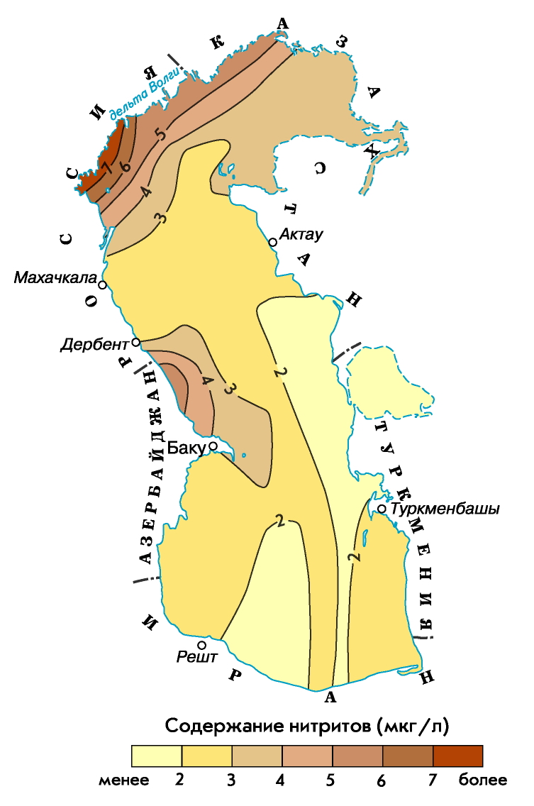
- high concentrations of nutrients are characteristic of the areas of the estuaries of rivers feeding the sea and shallow areas of the sea, subject to active anthropogenic influence (Baku Bay, Turkmenbashy Bay, waters adjacent to Makhachkala, Fort-Shevchenko, etc.);
- The North Caspian, which is a vast area of mixing of river and sea waters, is characterized by significant spatial gradients in the distribution of nutrients;
- in the Middle Caspian, the cyclonic nature of the circulation contributes to the rise of deep waters with a high content of nutrients into the overlying layers of the sea;
- in the deep-water regions of the Middle and South Caspian, the vertical distribution of nutrients depends on the intensity of the convective mixing process, and their content increases with depth.
The dynamics of nutrient concentrations throughout the year in the Caspian Sea is influenced by such factors as seasonal fluctuations in the nutrient runoff in the sea, the seasonal ratio of production and destruction processes, the intensity of exchange between soil and water mass, ice conditions in winter in the North Caspian Sea, winter processes. vertical circulation in deep sea areas.
In winter, a significant water area of the Northern Caspian is covered with ice, but biochemical processes are actively developing in sub-ice water and ice. The ice of the North Caspian, being a kind of accumulator of nutrients, transforms these substances entering the sea from and from the atmosphere.
As a result of the winter vertical circulation of waters in the deep-water areas of the Middle and South Caspian in the cold season, the active layer of the sea is enriched with nutrients due to their supply from the underlying layers.
Spring for the waters of the Northern Caspian is characterized by a minimum content of phosphates, nitrites and silicon, which is explained by the spring outbreak of phytoplankton development (silicon is actively consumed by diatoms). High concentrations of ammonium and nitrate nitrogen, characteristic of the waters of a large area of the Northern Caspian during floods, are due to intensive washing by river waters.
In the spring season, in the area of water exchange between the North and Middle Caspian in the subsurface layer, at the maximum oxygen content, the phosphate content is minimal, which, in turn, indicates the activation of the photosynthesis process in this layer.
In the South Caspian, the distribution of nutrients in spring is basically similar to their distribution in the Middle Caspian.
In summer, in the waters of the Northern Caspian, a redistribution of various forms of biogenic compounds is found. Here, the content of ammonium nitrogen and nitrates significantly decreases, at the same time there is a slight increase in the concentration of phosphates and nitrites and a rather significant increase in the concentration of silicon. In the Middle and South Caspian, the concentration of phosphates decreased due to their consumption in the process of photosynthesis and the difficulty of water exchange with the deep-water accumulation zone.
In autumn in the Caspian Sea, due to the cessation of the activity of some types of phytoplankton, the content of phosphates and nitrates increases, and the concentration of silicon decreases, as there is an autumn outbreak of the development of diatoms.
For more than 150 years, oil has been produced on the shelf of the Caspian Sea.
Currently, large hydrocarbon reserves are being developed on the Russian shelf, the resources of which on the Dagestan shelf are estimated at 425 million tons of oil equivalent (of which 132 million tons of oil and 78 billion cubic meters of gas), on the shelf of the North Caspian - at 1 billion tons of oil ...
In total, about 2 billion tons of oil have already been produced in the Caspian Sea.
Losses of oil and products of its processing during extraction, transportation and use reach 2% of the total volume.
The main sources of pollutants, including oil products, into the Caspian Sea are the outflow with river runoff, discharge of untreated industrial and agricultural wastewater, municipal wastewater from cities and towns located on the coast, shipping, exploration and exploitation of oil and gas fields. located at the bottom of the sea, transportation of oil by sea. Places of entry of pollutants with river runoff are 90% concentrated in the Northern Caspian, industrial effluents are mainly confined to the area of the Apsheron Peninsula, and increased oil pollution of the Southern Caspian is associated with oil production and oil exploration drilling, as well as with active volcanic activity (mud) in zone of oil and gas structures.
From the territory of Russia, about 55 thousand tons of oil products are annually supplied to the North Caspian, including 35 thousand tons (65%) from the Volga River and 130 tons (2.5%) from the Terek and Sulak rivers.
Thickening of the film on the water surface up to 0.01 mm disrupts the processes of gas exchange, threatens the death of the hydrobiota. Toxic for fish is the concentration of oil products 0.01 mg / l, for phytoplankton - 0.1 mg / l.

The development of oil and gas resources of the bottom of the Caspian Sea, the projected reserves of which are estimated at 12-15 billion tons of standard fuel, in the coming decades will become the main factor of anthropogenic pressure on the ecosystem of the sea.
Caspian autochthonous fauna... The total number of autochthons is 513 species or 43.8% of the entire fauna, which include herring, gobies, molluscs, etc.
Arctic species. The total number of the Arctic group is 14 species and subspecies, or only 1.2% of the entire fauna of the Caspian Sea (mysids, sea cockroach, white fish, Caspian salmon, Caspian seal, etc.). The basis of the Arctic fauna is made up of crustaceans (71.4%), which easily tolerate desalination and live at great depths of the Middle and South Caspian (from 200 to 700 m), since the lowest water temperatures are kept here throughout the year (4.9– 5.9 ° C).
Mediterranean species... These are 2 types of mollusks, needle-fish, etc. At the beginning of the 20s of our century, the mithielastr mollusk penetrated here, later 2 types of shrimp (with mullet, when acclimatized), 2 types of mullet and flounder. Some Mediterranean species entered the Caspian after the opening of the Volga-Don Canal. Mediterranean species play a significant role in the food supply for fish in the Caspian Sea.

Freshwater fauna (228 species). This group includes anadromous and semi-anadromous fish (sturgeon, salmon, pike, catfish, carp, as well as rotifers).
Marine species... These are ciliates (386 forms), 2 types of foraminifera. There are especially many endemics among higher crustaceans (31 species), gastropods (74 species and subspecies), bivalve molluscs (28 species and subspecies) and fish (63 species and subspecies). The abundance of endemics in the Caspian Sea makes it one of the most peculiar brackish water bodies of the planet.
The Caspian Sea provides over 80% of the world's sturgeon catches, the bulk of which is in the North Caspian.
To increase catches of sturgeon, which sharply decreased during the years of falling sea level, a set of measures is being carried out. Among them is a complete ban on fishing for sturgeon in the sea and its regulation in rivers, an increase in the scale of factory sturgeon breeding.
I would be grateful if you share this article on social networks:
The Caspian Sea is called the most big lake on our planet. It is located between Europe and Asia and is called the sea for its size.
Caspian Sea
The water level is 28m below the level. The water in the Caspian Sea has a lower salinity in the north in the delta. The highest salinity is observed in the southern regions.
The Caspian Sea covers an area of 371 thousand km2, the greatest depth is 1025 meters (South Caspian depression). The coastline is estimated from 6500 to 6700 km, and if we take it together with the islands, then more than 7000 km.
The seashore is mostly low and smooth. If you look at the northern part, there are many islands, water channels cut by the Volga and the Urals. In these places, the coast is swampy and covered with thickets. From the east, a semi-desert and desert area with limestone shores approaches the sea. The area of the Kazakh Bay, the Absheron Peninsula and the Kara-Bogaz-Gol Bay have winding shores.
Bottom relief
The bottom relief is divided into three main forms. The shelf is in the northern part, the average depth here is from 4 to 9 m, the maximum is 24 m, which gradually increases and reaches 100 m.The continental slope in the middle part drops to 500 m. Northern part the Mangyshlak sill separates from the middle one. Here is one of the most deep places Derbent depression (788 m).
2. Heraz, Babol, Sefudrud, Gorgan, Polerud, Chalus, Tejen - https: //site/russia/travel/po-dagestanu.html;
4. Atrek - Turkmenistan;
Samur - is located on the border between Azerbaijan and Russia, Astarachay on the border of Azerbaijan and Iran.
The Caspian Sea belongs to five states. From the west and north-west, the coast length of 695 km is the territory of Russia. Most of the 2,320 km long coastline belongs to Kazakhstan in the east and northeast. Turkmenistan has 1200 km in the southeastern part, Iran owns 724 km in the south and Azerbaijan owns 955 km of the coastline on the south-western side.
In addition to the five states that have access to the sea, Armenia, Turkey, and Georgia also belong to the Caspian basin. The Volga connects the sea with the World Ocean (Volga-Baltic route, White Sea-Baltic channel). There is a connection with the Azov and Black Seas through the Volga-Don Canal, with the Moscow River (Moscow Canal).
The main ports are Baku in Azerbaijan; Makhachkala; Aktau in Kazakhstan; Olya in Russia; Noushehr, Bander-Torkemen and Anzali in Iran.
The largest bays of the Caspian Sea: Agrakhan, Kizlyar, Kaidak, Kazakh, Dead Kultuk, Mangyshlak, Hasan-Kuli, Turkmenbashi, Kazakh, Gyzlar, Anzeli, Astrakhan, Gyzlar.
Until 1980, Kara-Bogaz-Gol was a lagoon bay, which was connected to the sea by a narrow strait. Now it is a salt lake, separated from the sea by a dam. After the construction of the dam, the water was old and sharply decreasing, so a culvert had to be built. Through it, up to 25 km3 of water gets into the lake annually.
Water temperature
The greatest temperature fluctuations are observed in winter. In shallow water it reaches 100 in winter. The difference between summer and winter temperature reaches 240. On the coast in winter it is always 2 degrees lower than in the open sea. Optimum water warming occurs in July-August, in shallow water the temperature reaches 320. But at this time the north-westerly winds raise cold water layers (upwelling). This process begins in June and reaches its intensity in August. The temperature at the surface of the water is dropping. The temperature difference between the layers disappears by November.
The climate in the northern part of the sea is continental, in the middle part - temperate, in the south - subtropical. Temperatures are always higher on the east coast than on the west. Once on the east coast, 44 degrees were recorded.
The composition of the Caspian waters
The salinity is about 0.3%. This is a typical desalinated pool. But the further south you go, the higher the salinity. In the southern part of the sea, it already reaches 13%, and in Kara-Bogaz-Gol more than 300%.
 Storms are frequent in shallow areas. They arise due to changes in atmospheric pressure. Waves can reach 4 meters.
The water balance of the sea depends on river flows and precipitation. Among them, the Volga accounts for almost 80% of all other rivers.
In recent years, there has been a rapid pollution of water with oil products and phenols. Their level has already exceeded the permissible level.
Minerals
Back in the 19th century, the beginning of the extraction of hydrocarbons was laid. These are the main Natural resources... There are also mineral, balneological biological resources here. Nowadays, in addition to gas and oil production on the shelf, sea-type salts (astrakhanite, mirabalite, halite), sand, limestone, and clay are mined.
Fauna and flora
The fauna of the Caspian Sea is up to 1800 species. Of these, 415 are vertebrates, 101 are fish species, there is a world stock of sturgeon. Freshwater fish such as carp, pike perch, roach also live here. They catch carp, salmon, pike, bream in the sea. The Caspian Sea is the habitat of one of the mammals - the seal.
Of the plants, blue-green algae, brown, red, can be noted. Zostera and ruppia also grow, they are referred to as flowering algae.
Plankton brought into the sea by birds begins to bloom in spring, the sea is literally covered with greenery, and rhizosolination during flowering paints most of the sea area in a yellow-green color. The accumulation of rhizosollenia is so dense that even waves can calm down. In some places near the coast, literally meadows of algae have grown.
Both local and migratory birds can be seen on the coast. In the south, geese and ducks winter, birds such as pelicans, herons, flamingos arrange nesting grounds.
The Caspian Sea contains almost 90% of the world's sturgeon stocks. But recently, the ecology has been deteriorating, and you can often find poachers who hunt sturgeon for expensive caviar.
States are investing a lot of money to improve the situation. They purify wastewater, build fish breeding plants, despite these measures, it is necessary to limit the production of sturgeon.


